Add your own picture and explain the route, parking, gates, paths or landmarks that help people find it.
Earn 5 points after the picture is checked and accepted.
Add your photo and local directionsShare what you foundWhat is recorded here
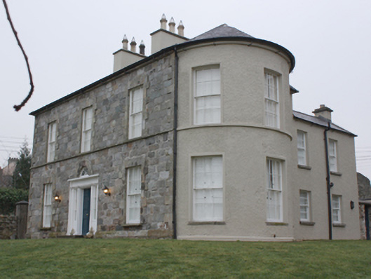
Detached three-bay two-storey house, built c. 1775, altered c. 1810 and c. 1870, and possibly containing earlier fabric, having two-storey return to the rear (west) at the south-west corner with single-storey extension attached to the west (former outbuilding?), two- and three-storey split level return to the rear at the north-west corner having later two-storey returns to the west, and with two-storey bowed projection attached to the north side elevation of main house. Later in use as a Presbyterian manse associated with adjacent church\meetinghouse (see 40800504). Recently renovated and now in use as a private house. Hipped natural slate roof to main body of building, semi-conical to bow to the north, having projecting cut stone eaves course, clay ridge tiles, a central pair of rendered chimneystacks with flat stone caps and moulded octagonal clay pots over, and with some surviving sections of cast-iron rainwater goods. Hipped natural slate roof to return to the south-west having projecting eaves course; hipped natural slate roof to three-storey return to the north-west having projecting eaves course; natural slate roods pitched natural slate roofs to extensions to the west having projecting eaves course and roughcast rendered chimneystacks to the west gable ends. Coursed squared dressed stone walls to front elevation having projecting chamfered cut stone plinth and raised ashlar block-and-start quoins to the corners. Roughcast rendered walls to other elevations; projecting smooth rendered plinth course to bowed projection to the north. Square-headed window openings to front elevation having raised ashlar block-and-start surrounds, stone sills, continuous cut stone sill course at first floor level, and with six-over-six pane timber sliding sash windows. Square-headed widow openings to bowed projection having stone sills at ground floor level, continuous skills at first floor level, smooth rendered surrounds, and with six-over-six pane timber sliding sash windows. Square-headed window openings to returns having timber sliding sash windows (two-over-two pane to top floor of west elevation of return, six-over-three pane to west elevation ground floor of return, two-over-two horizontal pane to extension), and mainly concrete sills. Central round-headed doorway to the centre of the front elevation having timber panelled double-doors with bolection mouldings, smooth rendered reveals, sidelights over timber panels, timber or stucco doorcase with engaged colonnettes and lintel cornice, entablature with plain frieze, and with spider’s web fanlight over with ashlar voussoirs. Ashlar limestone steps to entrance. Set back from road in extensive mature landscaped grounds to the south of the centre of Ramelton, and adjacent to the south of associated Presbyterian church (see 40800504). Lawns to the east and north. Site enclosed to east and north-east by rubble stone boundary wall, to the south by roughcast rendered boundary wall with cast-iron railings over having fleur-de-lys finials over, to the south-east by roughcast rendered boundary wall with rubble stone solider coping over, and to the west by roughcast rendered boundary wall. Pedestrian gateway to the south\south-east of house comprising a pair of smooth rendered ruled-and-lined gate piers (on square-plan) having metal gate. Modern vehicular gateway to the south-west comprising cement rendered ruled-and-lined gate pier to the east and roughcast rendered gate pier to the west (on square-plan) having cut stone coping over, and with modern metal gates; integral square-headed pedestrian gateway adjacent to the west.
This official record and map point do not grant access. Most recorded buildings are privately owned; view them only from public ground unless the owner allows entry.