Add your own picture and explain the route, parking, gates, paths or landmarks that help people find it.
Earn 5 points after the picture is checked and accepted.
Add your photo and local directionsShare what you foundWhat is recorded here
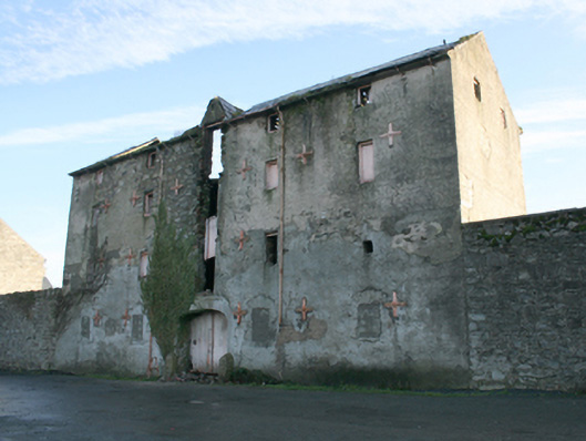
Detached five-bay four-storey former warehouse\store, built c. 1860, having gablet over central bay to the main elevation (west). Six-bay rear elevation (east) with gablet offset to the north side of centre. Now out of use and derelict. Pitched natural slate roof, now partially collapsing, having projecting ashlar eaves course, surviving sections of cast-iron rainwater goods, and clay ware ridge tiles. Pitched natural slate roof to gablet. Roughcast rendered rubble stone walls with flush roughly squared rubble stone quoins to the corners; cast-iron pattrice plates and wrought-iron tie bars to the front (west) and the rear (east) elevation. Square-headed window openings with rubble stone voussoirs, and remains of battened timber shutters. Ground floor window openings now blocked; rendered block-and-start surrounds to some ground floor openings. Central square-headed loading bays to the west elevation (beneath gablet), now largely collapsed. Central shallow segmental-headed carriage-arch to the west elevation having cement rendered block-and-start surround, battened timber double-doors, and with rock-faced granite wheel guards to either side having pyramidal heads and roughly drafted margins. Road-fronted to the north\north-east end of the Quay, Ramelton. River Leannan adjacent to the west. Complex of former warehouses\stores adjacent to the south (see 40800407 to 40800412) and warehouse to the north (see 40800405); section of rubble stone boundary wall attached to the south having rubble stone buttresses to the west face, and with integral segmental-headed carriage-arch to the south end having rubble stone piers (on square-plan), dressed and squared rubble stone voussoirs, and with a pair of wrought-iron flat bar gates. Yards to the north and south. Possibly incorporating fabric of castle and bawn to site to site (see RMP DG046-005007-) or possibly built using stone salvaged from same.
This official record and map point do not grant access. Most recorded buildings are privately owned; view them only from public ground unless the owner allows entry.