Add your own picture and explain the route, parking, gates, paths or landmarks that help people find it.
Earn 5 points after the picture is checked and accepted.
Add your photo and local directionsShare what you foundWhat is recorded here
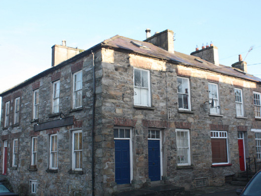
Corner-sited attached five-bay two-storey house over raised basement, built c. 1780, having two-bay two-storey over basement elevations to Shore Road (north) and to Bridge Street (south). Later in use as a public house and a restaurant. Now in use as a house. Hipped natural slate roof with clay ware ridge tiles, skylight to south elevation, smooth rendered chimneystack offset to the north side of the centre of the west elevation having decorative terracotta pots over, smooth rendered chimneystack to the east end of the south elevation having decorative terracotta pots over, and with cast-iron rainwater goods. Exposed rubble stone walls (formerly rendered) with flush roughly dressed quoins to the corners of the west elevation. Modern timber signboard to the west elevation. Square-headed window openings having red brick block-and-start surrounds and voussoirs, some surviving stone sills, and with six-over-six pane and four-over-four pane timber sliding sash windows. Square-headed window opening the south elevation at basement level having timber casement window with wrought-iron security bars; square-headed windows to the west elevation at basement level having timber casement windows. Two square-headed doorways to the west end of the south elevation (one probably formerly a window opening, later modified), having cut stone plinth blocks, replacement battened timber doors with bolection mouldings, and with tripartite overlights; doorways reached by flight of cut stone steps over basement level; cut stone threshold. Square-headed doorway to the north end of the west elevation having red brick block-and-start surrounds, replacement battened timber door, and with tripartite overlight; doorway reached by flight of cut stone steps over basement level having wrought-iron guard rails; cut stone threshold. Square-headed openings to the north elevation at basement level having red brick block-and-start surrounds and voussoirs, and with replacement battened timber doors. Road-fronted to the centre of Ramelton overlooking The Mall and Gamble’s Square to the west, Shore Road and the Leanne River to the north, and the west end of Bridge Street to the south. Plaque commemorating Dave Gallagher (1873-1917) attached to the north elevation.
This official record and map point do not grant access. Most recorded buildings are privately owned; view them only from public ground unless the owner allows entry.