Add your own picture and explain the route, parking, gates, paths or landmarks that help people find it.
Earn 5 points after the picture is checked and accepted.
Add your photo and local directionsShare what you foundWhat is recorded here
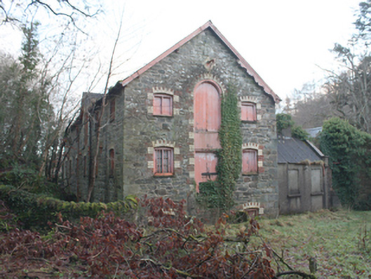
Detached six-bay four-storey former corn\flour warehouse\store, built c. 1873, having three-storey north elevation and four-storey south elevation, with gablets over loading bays to south elevation, and to central bay of north elevation. Incorporates two-storey block to the east end, built c. 1812. Three-bay three-storey extension to east (c. 1940), and single-storey link block to the south-west corner adjoining neighbouring building (see 408000303) at first floor level. Originally associated with earlier flour mill (see 40800301) adjacent to the south-east. Now out of use. Pitched natural slate roof with projecting stone eaves courses, remains of decorative timber bargeboards to west gable end, and with cast-iron rainwater goods. Pitched natural slate roof to earlier block adjoining to the east gable end having timber vent (on square-plan) to the apex at the west end having pitched covering and remains of timber louvers. Pitched corrugated-cement roof to later extension to the south-west end having rendered chimneystack and raised cement rendered verge to the south gable end with kneeler stone detail detailing. Roughly dressed rubble stone walls with flush roughly tooled block-and-start quoins to the corners; cast-iron tie\pattrice plates and wrought-iron tie plates to the north and south elevations. Plaque to site dated 21st of May 1873 (covered by vegetation, difficult to read), and having raised yellow brick surround. Shallow segmental-headed window openings having battened timber shutters with central timber mullions, and polychromatic yellow and red brick block-and-start surrounds and voussoirs; majority of ground floor openings now infilled with modern blockwork, wrought-iron security bars to ground floor and first floor window openings. Shallow segmental-headed door and loading bay openings having battened timber doors, and polychromatic yellow and red brick block-and-start surrounds and voussoirs; doors now infilled with modern blockwork. Some modern square-headed doorways with concrete lintels over. Rounded-headed loading bay to the centre of the west gable end at second floor level having battened timber double-doors, and polychromatic yellow and red brick block-and-start surrounds and voussoirs; metal pulley over having yellow brick surround (on circular-plan); square-headed doorway under at first floor level with battened timber double doors. Located in the rural countryside to the west of Ramelton town centre. Located on the north bank of Leannan River adjacent to the south-east of Drummonaghan Bridge (see 40800210) and former mill weir (see 40823002). Earlier mill buildings adjacent to the south-east (see 40800301) and to the south (see 40800303). Rubble stone wall to north-west corner with flight of rubble stone steps adjacent.
This official record and map point do not grant access. Most recorded buildings are privately owned; view them only from public ground unless the owner allows entry.