Add your own picture and explain the route, parking, gates, paths or landmarks that help people find it.
Earn 5 points after the picture is checked and accepted.
Add your photo and local directionsShare what you foundWhat is recorded here
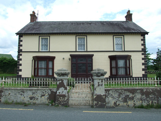
Detached three-bay two-storey house, built c.1830, with two-storey multiple-bay return to rear having single-storey lean-to to side. Pitched slate roof with clay ridge tiles, cast-iron rainwater goods, brick chimneystacks to gables and to rear extension, decorative timber fascias and bargeboards, cast-iron rainwater goods. Ruled-and-lined rendered walls to first floor with raised block-and-start quoins, string course at upper floor sill level, V-jointed stucco rustication to ground floor, rendered plinth course. Roughcast rendered walls to rear. One-over-one sliding sash windows to first floor with profiled surrounds to front first-floor window openings. Projecting timber-framed flat roofed glazed porch with panelled timber entrance door having glazed upper panels and single-pane overlight. Porch flanked by timber flat-roofed canted bay windows with one-over-one sash windows with stone sills on rendered plinths. Timber one-over-one sash windows to rear, patented reveals to later extensions and gables of original structure. Opens to shallow front garden with reclaimed sandstone flagstone paving, enclosed by cast-iron railings and gates flanked by rendered pillars. Yards and gardens to sides and rear, having rubble stone walls with rounded cement copings. Timber summer house in the manner of the entrance porch and bay windows, remains of glass house and boiler. Rubble stone outbuildings to west.
This official record and map point do not grant access. Most recorded buildings are privately owned; view them only from public ground unless the owner allows entry.