Add your own picture and explain the route, parking, gates, paths or landmarks that help people find it.
Earn 5 points after the picture is checked and accepted.
Add your photo and local directionsShare what you foundWhat is recorded here
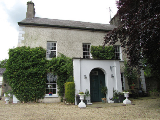
Detached three-bay two-storey with attic former barracks, built c.1660, with open porch, and two-storey return and narrow second pile to rear. Later in use as RIC barracks, now in use as private house. Pitched slate roof with later barge boards, flat roof to porch, replacement rainwater goods. Rendered chimneys to gables with individual square stacks above ridge level having decorative cappings. Brick chimney stack to rear slope and rendered stack to ridge of rear return. Roughcast rendered walls with block-and-start quoins to front elevation. Smooth rendered walls to rear and return. Six-over-six timber sash windows to front elevation. Six-over-three timber sashes to south-east gable. uPVC casements to rear. Window openings of various sizes to north-east gable. Stone sills to all windows. Smooth rendered walls to porch with round-arched opening, corner pilasters, and scotia moulding to parapet coping. Bipartite sash window to south-west side of porch with profiled central mullion flanked by narrow two-over-two timber sashes. Timber panelled door and screen set back in porch in line with centre mullion, fixed decorative overlight above entrance door. Opens onto stone paving in front of porch with low stone wall opposite forming a bowed terrace facing the River Erne. Rendered wing wall to east corner of house with pointed brick arch opening and metal gate to gardens beyond. Garden north of house with brick lined rubble stone wall. Corrugated-iron boat house south-west of bowed terrace with stone gable to landward side. Square-profile stone piers in rubble stone wall to east of house lead to elongated yard with single- and two-storey rubble stone outbuildings to south-west and north-east. Rubble stone sweep walls having plain stone piers with cappings and simple ironwork double gates.
This official record and map point do not grant access. Most recorded buildings are privately owned; view them only from public ground unless the owner allows entry.