Add your own picture and explain the route, parking, gates, paths or landmarks that help people find it.
Earn 5 points after the picture is checked and accepted.
Add your photo and local directionsShare what you foundWhat is recorded here
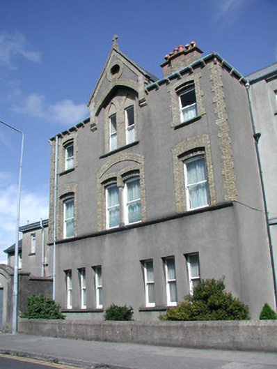
Attached multi-bay three-storey rendered presbytery, built 1912. Three-storey extension to south incorporating single-storey entrance porch, various two-storey extensions to north c. 1970. Hipped slate roof, clay ridge and hip tiles, brick corbelled chimneystack on unpainted smooth-rendered plinth, half-round cast-iron gutters on painted timber profiled eaves brackets. Forward-thrusting corbelled gabled dormer to west elevation, yellow brick and limestone dressings, incorporating oculus. Unpainted smooth-rendered walling, yellow brick quoins to upper floors. Tooled ashlar limestone walling to entrance porch, corbelled projecting panel incorporating carved plaque over segmental-headed recessed porch. Segmental-headed window openings to upper floors, double-recessed reveals to first floor, yellow brick dressings, masonry sills, continuous first floor sill course, blind pointed arches to paired second floor windows. Square-headed window openings to ground floor in two groups of three, stone sills. Painted one-over-one timber sash windows. Segmental-headed door opening to entrance porch, plain-glazed fanlight, painted timber double doors each with three panels. Entrance opens on to gravelled car park to south, unpainted smooth-rendered high wall to north with square-headed doorway set in pointed arch, carriage gateway to extreme north with sheeted gates, low smooth-rendered plinth boundary wall to immediate west, three-storey development to south.
This official record and map point do not grant access. Most recorded buildings are privately owned; view them only from public ground unless the owner allows entry.