Add your own picture and explain the route, parking, gates, paths or landmarks that help people find it.
Earn 5 points after the picture is checked and accepted.
Add your photo and local directionsShare what you foundWhat is recorded here
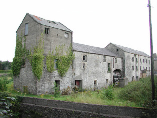
Former corn mill complex on the River Suck, built c.1725, now derelict. Comprising east-west running range, mill race and ancillary outbuildings to rear of site. Multi-period east-west running range comprises four abutting buildings. Seven-bay two and three-storey structure to east with concrete lean-to to north side. Abutting multiple-bay three-storey central building to west with blocked integral arch to west side and integral arch to east side containing iron mill wheel with timber paddles. Single-bay three-storey building to west end with concrete upper storey. Pitched slate and corrugated-iron roof with cast-iron rainwater goods. Random coursed stone walls with quoins and remains of roughcast render to walls. Yellow brick dressings to central section. Square-headed and some segmental-headed windows. Some remaining timber battened doors. Derelict outbuildings to rear of site, with remains of mill race. Mill complex set to side of road beside river. Bridge and road have been widened so only one original dressed limestone gate pier of entrance survives. Site now bounded by concrete wall. Former hydro-electric station to south of bridge.
This official record and map point do not grant access. Most recorded buildings are privately owned; view them only from public ground unless the owner allows entry.