Add your own picture and explain the route, parking, gates, paths or landmarks that help people find it.
Earn 5 points after the picture is checked and accepted.
Add your photo and local directionsShare what you foundWhat is recorded here
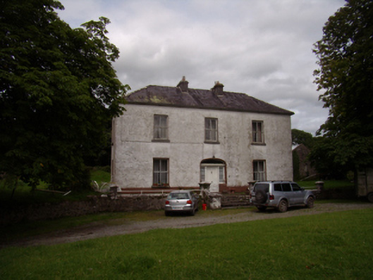
Detached three-bay two-storey house, built c.1770, having lower four-bay two-storey return to rear (north), slightly recessed. Hipped slate roof with some clay ridge tiles, and symmetrically placed pair of tooled limestone chimneystacks to main block, and red brick chimneystacks to addition. Roughcast rendered walls with smooth rendered plinth course, rubble limestone showing to addition. Square-headed timber sliding sash windows, two-over-two pane to front and three-over-three pane without horns to addition. Some recent timber casement windows to addition. Round-headed window opening to addition, having four-over-four pane timber sliding sash window. Tooled limestone sills throughout. Elliptical-headed door opening with timber doorcase having moulded timber cornice with carved brackets, plain overlight and two-pane sidelights with rendered stall risers, and timber panelled door with limestone threshold. Terrace at front of house approached by five tooled limestone steps with rendered parapets having curved limestone copings and cut limestone piers with pointed caps, and with rendered plinth wall to terrace with wrought-iron railing with cut limestone piers to front of house. Yard to rear. ng L-plan multiple-bay range attached to north end of house return, north-south part being open-sided lean-to shed and east-west part being multiple-bay single-storey with pitched corrugated-iron roof, rubble limestone walls, segmental vehicular entrance, and square-headed doorway and window opening. Multiple-bay two-storey east range, running north-south, almost abutting north L-plan range, has pitched corrugated-iron roof, rubble limestone walls, elliptical-arch throughway with yellow brick voussoirs and having red brick oculus above, and square-headed door and window openings, including pitching doors to east elevation and doorway in first floor of west accessed by external steps. Multiple-bay single-storey range further to north and parallel to east-west part of L-plan range, has loft floor, pitched slate roof, rubble limestone walls, segmental arch vehicular entrances and square-headed door and widnow openings. Some terracotta ridge tiles to slated buildings, and some cast-iron rainwater goods. Some replacement timber casement windows having render surrounds to east range. Pointed arch window opening to east elevation of east range. Recent metal stable doors to same range. Tooled voussoirs and dropped keystones to vehicular entrances of north blocks. Some remaining cobbles to courtyard. Icehouse to west of house, comprising earthen mound over rubble limestone structure with square-headed door opening. Three-bay single-storey gardener's lodge to south-west, having pitched roof lacking covering, with rubble limestone walls, and square-headed window and door openings. Wrought-iron double-leaf vehicular gate to road entrance, set to tooled limestone piers. Rubble limestone flanking walls and boundary walls to site. Benchmark to base of southern centre pier.
This official record and map point do not grant access. Most recorded buildings are privately owned; view them only from public ground unless the owner allows entry.