Add your own picture and explain the route, parking, gates, paths or landmarks that help people find it.
Earn 5 points after the picture is checked and accepted.
Add your photo and local directionsShare what you foundWhat is recorded here
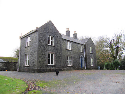
Detached four-bay two-storey farm house, built c.1855, having slightly advanced gabled end bays to front (north) elevation, two-bay west return elevation, one-bay east return elevation, single-bay block to east of and flush with latter, and with three-bay return to east again, with short separation between latter and single-bay single-storey porch to rear of east end of front block. Pitched slate roofs with cut limestone chimneystacks with terracotta and ceramic chimneypots. Cut-stone copings. Cut rough-faced snecked limestone walls with cut-stone plinth course and quoins, to front and east elevations, rendered walls elsewhere. Square-headed window openings throughout, with cut-stone surrounds and sills and timber sliding sash windows. Bipartite one-over-one pane windows to front elevation and east elevation of front block, horizontal-pane windows elsewhere, three-storey block having bipartite windows to middle bay and three-over-three-pane windows to ground floor, vertical six-over-six pane windows to rear elevation, and one-over-one pane to rear porch. Round-headed door opening with chamfered cut-stone surround with timber panelled door having decorative petal fanlight and cut-stone steps. Yard to rear with multiple-bay single- and two-storey outbuildings, some derelict or ruinous, having pitched slate roofs, rendered walls, and square-headed door openings. Largest building has pitching door with gabled dormer roof. Roofless ruinous remains of outbuilding to south-east, having external staircase, snecked cut-stone walls and square-headed openings with cut-stone dressings. Wrought-iron gate with dressed monolithic piers to south-east. Decorative cast-iron double-leaf gate to site entrance to north-east with square-plan cut-stone piers with pointed caps, with snecked quadrant walls and boundary walls with crenellated copings.
This official record and map point do not grant access. Most recorded buildings are privately owned; view them only from public ground unless the owner allows entry.