Add your own picture and explain the route, parking, gates, paths or landmarks that help people find it.
Earn 5 points after the picture is checked and accepted.
Add your photo and local directionsShare what you foundWhat is recorded here
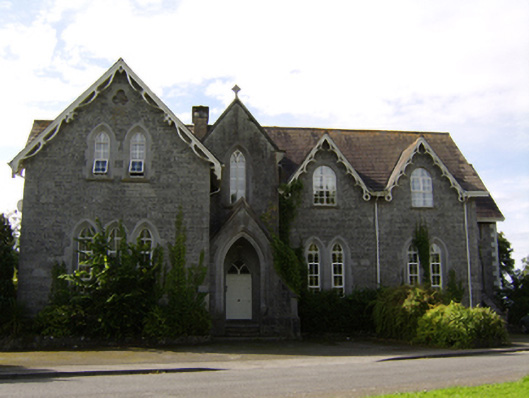
Detached irregular-plan two-storey over basement house with attic storey, dated 1855, and formerly Church of Ireland seminary. Faces north, having four-bay front elevation with projecting bay to east end, gabled entrance porch to re-entrant corner with dormer level, remaining two bays being slightly recessed, and with two-bay block recessed deeply back from front elevation. Rear elevation is six-bay, having western two bays recessed, remainder of façade having gabled roofs to next two bays. Basement raised to sides and rear. Now converted and in use as apartments. Pitched slate roofs with brick chimneystacks, gabled dormers to front with decoratively carved timber bargeboards. Cut-stone cross finial to gable of entrance bay. Snecked limestone walls having cut-stone quoins, rendered wall to upper floors of west gable. Pointed arch window openings with chamfered surrounds and cut-stone sills to front elevation, that to entrance bay being cusped double-light, and square-headed openings to other elevations, all with replacement uPVC windows. Trefoil opening with timber louvres to projection to front elevation. Pointed arch opening to entrance porch, with cut-stone surround, with pointed arch inner door opening, having replacement door and Y-tracery overlight. Cut-stone steps with cut-stone retaining walls. Elliptical-headed door opening to recessed bay to west end of front elevation, having timber panelled door, approached by cut limestone steps and retaining walls. Site entrance comprising cut, tooled and chamfered limestone piers with vegetal detail to stops, with flanking square-headed pedestrian entrances having lintels, with cast-iron vehicular and matching pedestrian gates, all with hinges in form of human hand, and flanked by rubble walls with edge-set coping stones.
This official record and map point do not grant access. Most recorded buildings are privately owned; view them only from public ground unless the owner allows entry.