Add your own picture and explain the route, parking, gates, paths or landmarks that help people find it.
Earn 5 points after the picture is checked and accepted.
Add your photo and local directionsShare what you foundWhat is recorded here
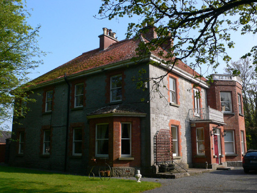
Detached three-bay two-storey former rectory, built c.1880, facing south-east and having canted projecting bay to end of façade, projecting shallow porch to middle bay, and four-bay south-west elevation with canted bay window to front end. Flat-roofed addition to re-entrant corner of rear. Now in use as private house. Hipped tiled roof with cast-iron rainwater goods and red brick chimneystacks, two being centrally located to front block. Hipped tiled roof to canted bay window and flat balustraded roof to canted bay, latter having brick cornice. Coursed rubble limestone walls with cut-stone quoins plinth, canted bay and bay window having red brick walls. Square-headed window openings with red brick surrounds, one-over-one pane timber sliding sash windows and limestone sills. Porch has decorative cast-iron balcony, timber panelled door with glazed sidelights and overlights and square-headed one-over-one pane timber sliding sash window to south-west side of porch, and with liemstone step to front. Yard to rear of house bounded by coursed rubble limestone walls and having square-headed pedestrian entrance, and vehicular gateway comprising dressed limestone piers with caps and double-leaf timber gate. Nine-bay single-storey outbuidling to north-west side of yard having two three-bay parts to north-east end. Pitched slate roof, red brick chimneystack, red brick walls, square-headed widnows and doorways with fixed timber windows, limestone sills and timber battened doors, and segmental carriage arch with double-leaf timber battened door. Gateway to road comprises coursed rock-faced limestone piers with caps and ball finials supporting double-leaf wrought-iron gate and flanked by low similar walls with vertical coping stones and terminated by low piers with caps and ball finials.
This official record and map point do not grant access. Most recorded buildings are privately owned; view them only from public ground unless the owner allows entry.