Add your own picture and explain the route, parking, gates, paths or landmarks that help people find it.
Earn 5 points after the picture is checked and accepted.
Add your photo and local directionsShare what you foundWhat is recorded here
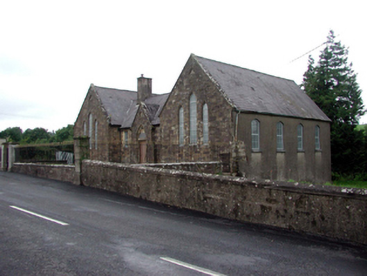
Detached five-bay single-storey over basement national school, dated 1870, on a H-shaped plan retaining some original fenestration comprising three-bay single-storey central block with single-bay single-storey gabled advanced porch to centre, and single-bay single-storey gabled advanced flanking end bays having four-bay single-storey side elevations (forming single-bay single-storey 'returns' to north-east). Extended, c.1945, comprising three-bay single-storey lean-to lower infill range to rear (north-east) elevation. Part refenestrated, c.1995, to accommodate use as parish hall. Pitched slate roofs on a H-shaped plan with clay ridge tiles, rendered chimney stacks, cut-stone coping, and cast-iron rainwater goods. Lean-to artificial slate roof to additional range. Broken coursed squared sandstone walls to front (south-west) elevation with buttresses to porch, and trefoil recessed panels to gables. Unpainted roughcast walls to remainder with exposed random squared rubble stone construction to ‘return’ to south. Square-headed window openings to central block with chamfered sills and reveals. Replacement uPVC casement windows, c.1995. Lancet window openings to end bays (in tripartite arrangement to front (south-west) elevation, and paired to rear (north-east) elevation) with chamfered sills and reveals. 9/9 timber sash windows with most having replacement uPVC casement windows, c.1995. Shallow segmental-headed window openings to side elevations with stone sills, and replacement uPVC casement windows, c.1995. Square-headed window openings to additional range with concrete continuous sill, and replacement uPVC casement windows, c.1995. Square-headed door openings with tongue-and-groove timber panelled doors, and pointed trefoil overpanel to porch having date stone/plaque. Set back from line of road in own grounds with grass forecourt having rendered piers with wrought iron gates, and sections of wrought iron flanking railings on random rubble stone plinth wall forming boundary to perimeter of site. Enclosed grounds to rear (north-east) with additional range approached by pair of flights of steps originally providing separate access to courtyards.
This official record and map point do not grant access. Most recorded buildings are privately owned; view them only from public ground unless the owner allows entry.