Add your own picture and explain the route, parking, gates, paths or landmarks that help people find it.
Earn 5 points after the picture is checked and accepted.
Add your photo and local directionsShare what you foundWhat is recorded here
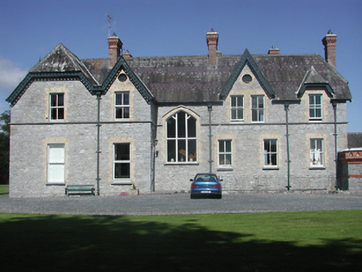
Detached asymmetrical six-bay two-storey over basement Victorian house, dated 1863, with variously-sized gablets to all elevations. Western two bays projecting, with entrance doorway in eastern return wall. Two-storey canted bay to northwest and single-storey addition to southeast corner. Half-hipped slate roof with fish-scale pattern slates, ridge crestings, carved timber bargeboards, decorative brick chimneystacks and cast-iron rainwater goods. Exposed limestone rubble walls brought to courses. Square-headed window openings with brick surrounds and with timber sliding sash windows, mainly two-over-two pane, but with some one-over-one pane to rear and north gable. Cut-stone sills to ground floor and continuous sill course and string course to all elevations on first floor. Bull's-eye openings with brick surrounds and timber louvres to some gablets. Large pointed triangular-headed replacement timber window to south elevation. Carved pointed-arch doorcase with timber panelled door. Two-storey outbuildings attached to northeast corner with hipped slate roofs, limestone rubble walls and square-headed and segmental-arch openings and decorative brick chimneystacks. Snecked limestone gateway to public road with central vehicular arch flanked by pedestrian archways with pilasters, intrados and keystones, date to centre one, and decorative cast-iron gates.
This official record and map point do not grant access. Most recorded buildings are privately owned; view them only from public ground unless the owner allows entry.