Add your own picture and explain the route, parking, gates, paths or landmarks that help people find it.
Earn 5 points after the picture is checked and accepted.
Add your photo and local directionsShare what you foundWhat is recorded here
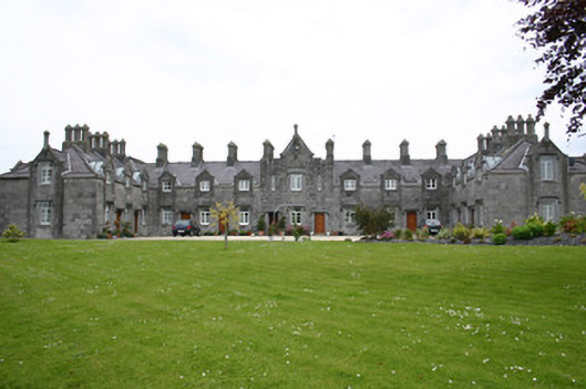
Detached multiple-bay dormer two-storey block of limestone almshouses, built between 1826-27, forming three interconnecting wings, arranged on a U-plan, comprising nine residences which open onto a courtyard. The end bays formerly housed a male and a female national school. Raised gabled centrepiece with a crenellated parapet surmounted by limestone Tudor inspired finial, and accommodating a clock face. Hipped slate roof and clay ridge tiles. Glazed pitched roofs to half-dormers, c. 1995. Limestone chimneystacks with multiple diamond-shaped pots rising from bases. Concealed gutters and downpipes to courtyard elevation, cast-iron rainwater goods to rear. Hammer dressed squared and snecked limestone walls with tooled limestone ashlar details. Square-headed window openings, with limestone ashlar drip moulds to ground floor openings, all having chamfered reveals, flush sills, with replacement uPVC casement windows. Pointed-arch lancet windows to centrepiece with chamfered reveals, flush sills, and fixed metal window frames. Square-headed door openings with limestone ashlar drip moulds, stopped-chamfer reveals, limestone platform, and replacement plank timber doors. Plaque to gable of centrepiece reads: 'These alms houses and schools endowed by Mrs. Hannahh Villiers were erected by her trustees the Revd John Duddell and the Rev John Pinkerton A.D.1826'. Located within grounds with garden and modern boundary railing to west. Substantial remnant of city walls to north, high stone wall to east. Single-storey gate lodge and gateway with stout limestone piers to south. Lean-to hammer finished limestone offices to north and east. Located adjacent to Saint Munchin's Church of Ireland churchyard.
This official record and map point do not grant access. Most recorded buildings are privately owned; view them only from public ground unless the owner allows entry.