Add your own picture and explain the route, parking, gates, paths or landmarks that help people find it.
Earn 5 points after the picture is checked and accepted.
Add your photo and local directionsShare what you foundWhat is recorded here
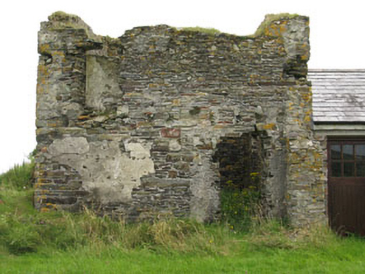
Freestanding two-bay two-stage square-profile signal tower, built c.1805. Now ruinous with upper stage missing, having later two-bay single-storey addition to side (west). L-plan stairwell to side (east) and rear (south) elevations, formerly granting access to upstage door opening (now absent). Roof missing to tower, pitched slate roof to side addition, having timber-clad eaves course and uPVC rainwater goods. Rubble stone walls throughout, having intermittent sections of roughcast render and slate hanging. English bond red brick parapet wall to stairwell. Cast-iron tie beams to sides (east, west) with bolts visible to side (east) elevation. Square-headed window openings throughout with dressed limestone voussoirs to tower, sills now absent. Red brick block-and-start surround and voussoirs to addition having timber-framed three-pane casement window. Square-headed door openings to tower, surrounds in poor state with lintels absent. Square-headed door openings to addition having red brick surround and replacement glazed timber and double-leaf timber battened doors. Former window and door openings visible to interior having stone voussoirs. Red brick hearth to interior of front wall. Ruinous outbuilding to south-east, having remains of rubble stone walls with sections of roughcast render. Recent four-bay single-storey former outbuilding to south-west, renovated and in use as house. Located on and elevated site with rubble stone enclosing wall. Square-profile gate piers with rubble capping to west of site.
This official record and map point do not grant access. Most recorded buildings are privately owned; view them only from public ground unless the owner allows entry.