Add your own picture and explain the route, parking, gates, paths or landmarks that help people find it.
Earn 5 points after the picture is checked and accepted.
Add your photo and local directionsShare what you foundWhat is recorded here
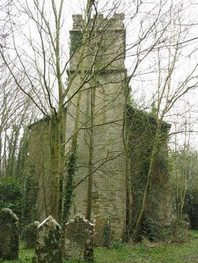
Freestanding double-height Church of Ireland church, rebuilt 1876, containing fabric of earlier structure, built c.1700, comprising three-bay nave with three-stage bell tower to front (west) and vestry to side (north). Now ruinous. Pitched gables to nave, roof gone, with remains of tooled stone copings to gables. Crenellated parapet wall with tooled stone capping to bell tower. Lean-to roof to vestry. Rendered rubble stone walls. Tooled limestone string courses to second and third stages of bell tower having blind quatrefoil recesses to side (north, east and south) elevations of third stage. Pointed arch window openings having tooled limestone sills and rendered reveals to side (south) and rear (east) elevations. Pointed arch openings to side (north, south and west) elevations of first-stage of bell tower, formerly accommodating timber louvers. Square-headed ventilation openings to side (south, north) and rear (east) elevations. Pointed arch door opening having raised render surround, tooled limestone plinth blocks and rendered stepped approach with rendered parapet walls, now blocked with rubble stone. Square-headed door opening to side (west) elevation of vestry with rendered reveal and stone block stepped approach, now blocked. Set in graveyard. Rubble stone walls to north, south and east and rendered rubble stone walls with square-profile piers, tooled limestone capping with cast-iron gates to west. Ruin of gatehouse to south side of entrance. Later graveyard to south-west enclosed within rendered walls with plinth, square-profile piers with render string course, moulded cornice and triangular capping with inscribed date of AD 1900.
This official record and map point do not grant access. Most recorded buildings are privately owned; view them only from public ground unless the owner allows entry.