Add your own picture and explain the route, parking, gates, paths or landmarks that help people find it.
Earn 5 points after the picture is checked and accepted.
Add your photo and local directionsShare what you foundWhat is recorded here
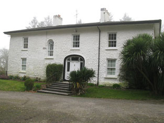
Freestanding four-bay two-storey over basement country house, built c.1800. Hipped slate roof with rendered chimneystacks, rendered stone block eaves course, timber cladding to eaves and cast-iron down pipes with replacement uPVC rainwater goods. Roughcast render over slate hanging walls throughout with rendered rubble stone plinth and sections of later render. Square-headed window openings having tooled stone sills, rendered reveals, and replacement six-over-six pane uPVC sliding sash windows throughout, two-over-two pane timber sliding sash windows and timber casement window to basement level of side (north-east) elevation. Round-headed stairwell window opening to front (south-east) elevation having tooled stone sill, rendered reveals and replacement six-over-four pane uPVC sliding sash window with spoked fanlight to upper sash. Central elliptical arch door opening to front elevation within raised moulded render surround and tooled limestone stepped approach with decoratively carved steps and later wrought-iron hand rails with recesses for original rails. Timber panelled door with brass fittings flanked by glazed timber panelled sidelights, surmounted by tripartite overlight with decorative brass carriage lamps. Square-headed door opening to side (north-east) elevation having replacement uPVC door and overlight accessed via rendered Ballustraded flat concrete bridge spanning basement area. Square-headed door opening with timber battened door to basement. Rubble stone parapet walls with rubble stone coping enclosing basement area with rendered steps and concrete paving to basement. Two external underground storage bunkers to north-east of house having red brick lined walls and vaulted roofs with square- and camber-headed door openings to west elevation of basement area. Extensive derelict farmyard located to the south-east comprising of eight-bay two-storey stable block, six-bay two-storey barn attached to south-east of stable block and later stable block enclosing stone cobbled courtyard. Site is enclosed by rubble stone boundary walls with recent gateway having iron girder and concrete bridge to north-west. Original gateway to north comprising of rubble stone walls with tooled limestone plinth, channelled gate piers with cornice and capping holding decorative cast-iron gates. Double-arch bridge spanning tributary of Owenboy River immediately to south of entrance gates, having rounded-headed arches with dressed stone voussoirs, rubble stone piers, spandrels and recent rubble stone parapet walls. Original S-shaped plan driveway parallel to stream having gateway at intersection with new driveway.
This official record and map point do not grant access. Most recorded buildings are privately owned; view them only from public ground unless the owner allows entry.