Add your own picture and explain the route, parking, gates, paths or landmarks that help people find it.
Earn 5 points after the picture is checked and accepted.
Add your photo and local directionsShare what you foundWhat is recorded here
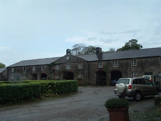
Outbuildings to rear (north) of Longueville House, erected c. 1780, comprising symmetrical arrangement of three detached ranges of two-storey buildings set around rectangular-plan courtyard. East range converted to domestic accommodation. North range has thirteen-bay ground and eleven-bay first floors, with three-bay pedimented breakfront having segmental-arched vehicular entrances to centre and to first two flanking bays of rest of façade. Hipped slate roof with rendered and slate-hung chimneystack. Pediment has inset glazed clock having painted face with Roman numerals and iron hands, and openwork bellcote above having brass bell. Coursed sandstone walls having some roughcast render. Square-headed window and door openings having some limestone sills and replacement timber casement windows and timber battened doors with tooled limestone surrounds. Brick surrounds to vehicular entrances. Seven-bay east and west ranges, having single-bay breakfronts. Part basement to west range. Hipped slate roofs having rendered and slate-hung chimneystacks. Coursed rubble stone walls, having recessed roundels to pediments. Square-headed window openings with brick surrounds and limestone sills, west range having six-over-three pane timber sliding sash windows, tripartite to first floor of breakfront, and east range having replacement timber windows. Elliptical-arch openings to breakfronts with brick voussoirs, having timber window and timber battened door to west range and glazed timber door and sidelights to east range, latter also having cast-iron railigs on limestone plinth walls with limestone steps. Coursed rubble-stone boundary wall to south-west terminating in square-plan piers with spherical pediments. Walled garden to east, laid out 1829, having coursed rubble stone walls, square-headed entrance with cast-iron gate. Square-plan water tower to north-west corner of garden attached to garden wall, having coursed rubble sandstone and limestone walls, square-headed latticed window having hood-moulding, and cistern of iron sheets with round-headed iron rivets and iron reinforcement bars. Detached lean-to outbuilding to west, with lean-to corrugated-iron roof, and having two-bay single-storey coursed sandstone walled section to east, with multiple-bay corrugated-iron section to west, and open to east elevation, with square-headed door openings having timber battened and corrugated-iron doors.
This official record and map point do not grant access. Most recorded buildings are privately owned; view them only from public ground unless the owner allows entry.