Add your own picture and explain the route, parking, gates, paths or landmarks that help people find it.
Earn 5 points after the picture is checked and accepted.
Add your photo and local directionsShare what you foundWhat is recorded here
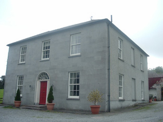
Detached three-bay two-storey house, built c. 1820, burnt down and restored c. 1910 to original design, having three-bay side elevations and single-bay two-storey projection to rear, with attached outbuildings. Hipped slate roof with clay ridge tiles and rendered chimneystacks with some terracotta chimney pots. Limestone ashlar front (south) elevation with limestone plinth course, and painted roughcast rendered walls elsewhere with smooth rendered plinth course and cast-iron vents. Square-headed window openings, with one round-headed window to rear, having replacement limestone sills and replacement uPVC sash windows throughout. Round-headed entrance doorway flanked by fluted columns with limestone plinths, and having timber panelled door and spoked fanlight, approached by two limestone steps. Recent uPVC lean-to conservatory to rear. L-shaped range of outbuildings to rear of house having pitched slate roof with clay ridge tiles, painted roughcast rendered walls and square-headed openings with replacement uPVC windows and halved timber battened doors. Elliptical-arched vehicular entrances having replacement metal doors. Detached two-bay two-storey outbuilding to rear having pitched slate roof with clay ridge tiles and elliptical-arched and square-headed vehicular entrances with red brick voussoirs. Square-plan coursed rubble stone piers with replacement timber gate to north. Roughcast rendered angled entrance walls terminating in square-plan rendered piers having limestone plinths to south of house, having benchmark to east pier plinth.
This official record and map point do not grant access. Most recorded buildings are privately owned; view them only from public ground unless the owner allows entry.