Add your own picture and explain the route, parking, gates, paths or landmarks that help people find it.
Earn 5 points after the picture is checked and accepted.
Add your photo and local directionsShare what you foundWhat is recorded here
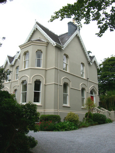
Detached five-bay two-storey over basement house, built 1870, having projecting gabled entrance and end bay to front elevation. Gabled end bay to south elevation with full-height canted bay, recessed single-bay two-storey over basement addition and conservatory to west. Pitched slate roof having cast-iron crestings, rendered chimneystacks and painted timber bargeboards with trefoil and quatrefoil motifs. Rendered walls with render plinth course. Square-headed openings to recessed-bay, front elevation having one-over-one pane timber sliding sash windows, painted stone sills to ground floor and render continuous sill course to first floor. Shouldered openings with one-over-one pane timber sliding sash windows, having painted stone sills and continuous hood moulding course to ground floor windows, and continuous sill course to first floor. Shouldered openings to basement with one-over-one pane timber sliding sash windows and cast-iron grills. Pointed arch opening having chamfered surround and overlights over timber panelled door. Flanking sidelights with panelled risers. Flight of limestone steps to entrance having painted balustrades and square-profile rendered piers. Railings to front elevation, basement level with rendered steps leading to square-headed half-glazed timber panelled door. Pair of square-profile brick piers with limestone platband, caps and plinths. Rubble limestone boundary walls having render copings.
This official record and map point do not grant access. Most recorded buildings are privately owned; view them only from public ground unless the owner allows entry.