Add your own picture and explain the route, parking, gates, paths or landmarks that help people find it.
Earn 5 points after the picture is checked and accepted.
Add your photo and local directionsShare what you foundWhat is recorded here
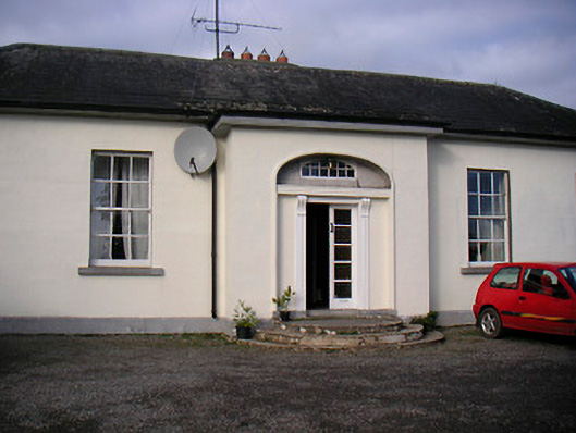
Detached five-bay single-storey house, built c.1845, with a shallow projecting porch to the centre of the front façade (east). Single-storey return and extensions to the west and a complex of outbuildings to the south. Hipped slate roof with overhanging eaves and rendered chimneystacks, aligned parallel to roof ridge behind roof level. Ruled-and-line rendered walls over projecting cut stone plinth. Square-headed window openings having six-over-six pane timber sliding sash windows and tooled limestone sills. Segmental-headed door opening to projecting porch having timber pilasters with console brackets flanking replacement glazed timber double doors. Fanlight over has been infilled and replaced by a fanlight with lattice glazing pattern, moved from one of the outbuildings to the south. Three limestone steps, semi-circular in plan, descend to gravel forecourt. Complex of roughcast rendered rubble limestone outbuildings with to the south, with hipped and pitched natural slate roofs and square-headed openings to the south arranged around a U-shaped enclosure. Complex entered through gateway to the south of the house, comprising limestone gate piers on square plan with cut stone coping over. Main entrance to house to the north of the house, comprising six dressed limestone gate piers, square in plan with cut stone coping over, joined by sections of rubble limestone walling. Inner piers support cast-iron double gates and are flanked to the north and south by curved plinth walls with cast-iron railings over. Approach avenue from the northeast goes over single-arched rubble limestone bridge with dressed limestone voussoirs and cut limestone coping over parapets. Opposite the entrance, on the other side of the road (west), is a semi circular carriage turning bay associated with the main entrance gates, bounded by a rubble stone wall which is now overgrown with vegetation. Stone wheel guards flank the entrance. To the north is a stone well with steps leading down the cut stone hollow. This was built, c.1850, so the locals could collect water from the well without entering the grounds of Washford House. Located to the east of Ballymore and the northwest of Loughanavally.
This official record and map point do not grant access. Most recorded buildings are privately owned; view them only from public ground unless the owner allows entry.