Add your own picture and explain the route, parking, gates, paths or landmarks that help people find it.
Earn 5 points after the picture is checked and accepted.
Add your photo and local directionsShare what you foundWhat is recorded here
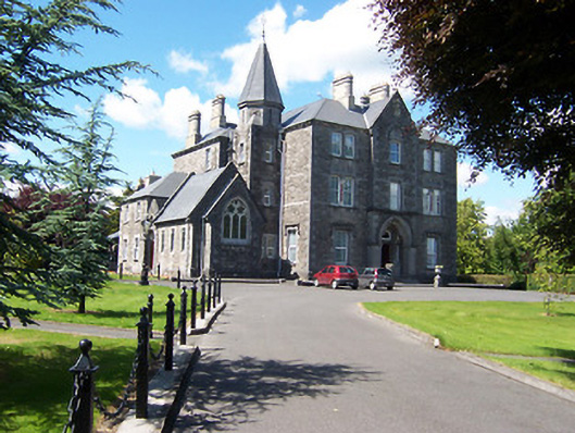
Detached three-storey bishop’s palace on irregular plan, built c.1873. Comprises a three-bay three-storey block to the east end with an advanced single-bay gable-fronted breakfront to the centre. Single-storey double-height gable-fronted chapel attached to the west side of three-storey block having a four-storey tower on square-plan rising to an octagonal slate-spire over to the east side. Two and three-storey blocks to the rear and to the northwest corner. Steeply pitched natural slate roof with overhanging eaves supported on cut stone brackets with yellow brick eaves courses and having yellow brick chimneystacks with ashlar limestone trim. Raised verges to either gable end of chapel with cut stone Celtic cross finial over south gable end. Constructed of rusticated coursed and snecked limestone over projecting cut stone plinth and having extensive cut/dressed stone trim, including surrounds to the openings, quoins to the corners, string courses and sill courses. Carved stone crest to apex of gable-fronted section. Square-headed window openings to main body of building with replacement windows. Triple-light Decorated Gothic window to the south gable end of chapel having cut stone tracery and stained glass windows. Cusped window openings with stained glass windows to west elevation of chapel. Pointed-arched doorcase to projecting bay to the centre of section to the east having cut stone surround with inset cusped-head, timber double doors, segmental-headed overlight and having a cut stone hoodmoulding over. Pointed-arched doorcase with cut stone surround and detailing to the north end of the west elevation of chapel. Set back from road in extensive mature landscaped grounds, shared with adjacent cathedral (15310166), with the main entrance gates to the southeast (15310163). Located to the north of Mullingar Town centre.
This official record and map point do not grant access. Most recorded buildings are privately owned; view them only from public ground unless the owner allows entry.