Add your own picture and explain the route, parking, gates, paths or landmarks that help people find it.
Earn 5 points after the picture is checked and accepted.
Add your photo and local directionsShare what you foundWhat is recorded here
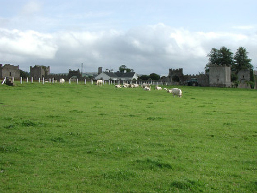
Ruinous elevations of demolished Franckfort Castle, built c.1730, with Gothic style curtain wall with entrance gates and corner towers, central outbuildings to two cobbled yards and walled field to east. Now enclosing 1970s bungalow within a modern farm. Random coursed curtain walls with castellated parapet enclose site of demolished country house, having main entrance gate to north wall, ancillary gate to east of main gate, gate to east leading to central farm yard, gate to south leading to southern yard and four corner towers. Main entrance gate comprises drop-arched carriage opening with ashlar stone walls, pulvinated string course and castellated parapet, built c.1817. Ancillary gate to east of main gate comprises segmental-headed carriage opening with ashlar walls, pulvinated string course, castellated parapet with ball finials and date plaque to exterior of gate reading 1817. Gate to central farmyard in eastern wall comprises random coursed walls, segmental-headed opening with timber battened doors and surmounting pointed-arched bellcote. Date plaque to exterior of gate reads 1732. Gate to south wall of southern yard comprises segmental-headed opening with snecked walls, string course, cut stone voussoirs and castellated parapet. Two-storey square-profile corner towers to curtain wall with random coursed and roughcast rendered walls having castellated parapets. Tudor Gothic tracery to timber casement windows to north-eastern tower. Two ranges of L-plan former stables and outbuildings to central cobbled farmyard. Range to west of yard with half-hipped slate roofs, ashlar chimneystacks and brick arch openings, now derelict. Range to east of yard with corrugated-iron roof added and abutted by corrugated-iron shed. Pointed-arched carriage opening with cut stone voussoirs leads from central farmyard to southern yard, having single-storey stone outbuildings. Ruinous partial exterior elevations of demolished country house to centre of site, having random coursed walls with string course to plinth. Walled field to with random coursed walls.
This official record and map point do not grant access. Most recorded buildings are privately owned; view them only from public ground unless the owner allows entry.