Add your own picture and explain the route, parking, gates, paths or landmarks that help people find it.
Earn 5 points after the picture is checked and accepted.
Add your photo and local directionsShare what you foundWhat is recorded here
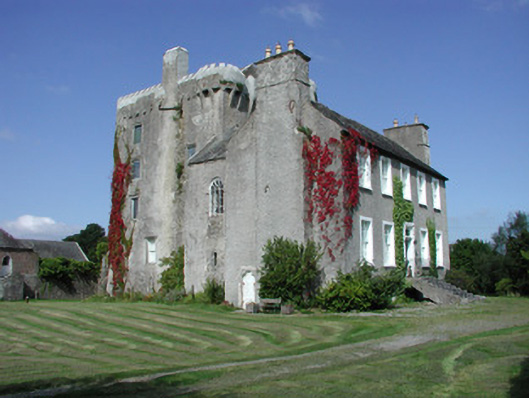
Detached T-plan five-bay two-storey over basement county house, built c.1700, abutting renovated five-storey rectangular-plan tower house to west. House having pitched slate roof with terracotta ridge tiles and roughcast rendered chimneystacks with yellow terracotta pots. Roughcast rendered walls. Timber sash windows to façade with stucco surrounds. Round-headed timber sash window to south elevation of return. Gothic style timber fanlight to blocked up door opening on northern elevation of return with intersecting glazing bars. Square-headed door opening to façade having pilastered stucco surround, timber panelled door with stained glass panes door and spoked fanlight. Triangular-headed door opening to south gable of house with round-headed metal door. Rectangular-plan tower house with circular stair turret at its north-east angle. Pitched slate roof with castellated parapet and bartizans to south-east and north-west corners and stone chimneystack over north and elevations. Roughcast rendered walls with loop openings and corbels to north elevation carrying oversailing garderobes and mural passages. Machicoulations to east formerly defended entrance, now masked by house. Castellated porch to west of tower-house. Square-headed window openings inserted to tower house. Yard to west with ranges of stone outbuildings to west having pitched slate roofs. Yard accessed from north through wrought-iron gates. Wall to south of tower. Stone and brick outbuilding to south half-hipped slate roof and external stairs with date plaque reading ‘JTS 1883’. Adjacent stone wall with round-headed opening with tooled stone surround and wrought-iron gate, accessing yard, surmounted by bellcote. Walled garden to south west of house. Ashlar gate piers with carved caps and sweeping walls to road.
This official record and map point do not grant access. Most recorded buildings are privately owned; view them only from public ground unless the owner allows entry.