Add your own picture and explain the route, parking, gates, paths or landmarks that help people find it.
Earn 5 points after the picture is checked and accepted.
Add your photo and local directionsShare what you foundWhat is recorded here
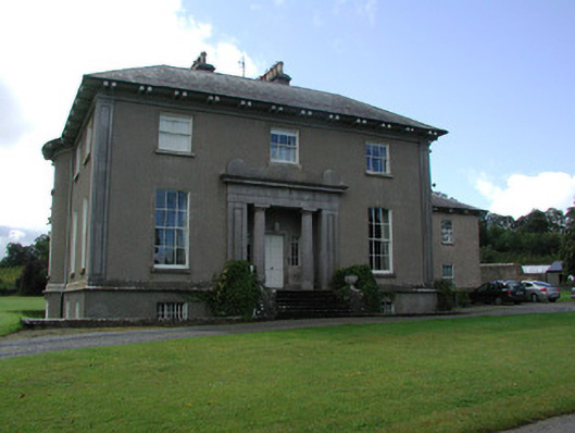
Detached three-bay two-storey over raised basement country house, built c.1820, with bow to west-facing side elevation and recessed entrance porch. Three-bay two-storey wing to east, added c.1870. Hipped slate roof with limestone chimneystack, cast-iron rainwater goods and an open eaves. Roughcast rendered walls with tooled limestone plinth course, limestone eaves course and panelled pilasters to corners stretching from ground floor to eaves. Camber-arched window openings to ground floor, square-headed window openings to basement and first floor with tooled limestone sills and timber sash windows. Round-headed stair light and bull's eye windows to east-facing side elevation. Canted bay window to additional wing. Square-headed door opening with limestone architrave surround and timber panelled door flanked by sidelights and set within a Neo-Greek propylaeum with fluted Doric columns and cornice. Door accessed up six limestone steps flanked by decorative cast-iron railings. Walled garden to south-west of house with pedimented limestone Ionic door surround incorporated. Cobbled yard accessed through arched opening with ranges of single and two-storey outbuildings. Wrought-iron gates supported by cast-iron piers to front site of house. Limestone panelled gates piers to road support replacement wrought-iron gates and railings. Former gate lodge adjacent.
This official record and map point do not grant access. Most recorded buildings are privately owned; view them only from public ground unless the owner allows entry.