Add your own picture and explain the route, parking, gates, paths or landmarks that help people find it.
Earn 5 points after the picture is checked and accepted.
Add your photo and local directionsShare what you foundWhat is recorded here
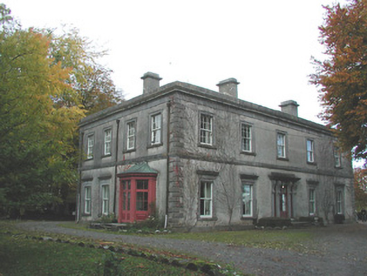
Detached five-bay two-storey double-pile country house, built in 1854, with farmyard and walled garden to north. Situated in its own extensive grounds. Hipped slate roof with terracotta ridge tiles, rendered chimneystacks and cast-iron rainwater goods, roof hidden behind parapet. Roughcast rendered walls with tooled limestone plinth, quoins, string course and frieze and cornice to parapet. Timber sash windows with tooled limestone surrounds and sills, ground floor window surrounds surmounted by frieze and cornice. Round-headed stairlight to western elevation with timber sash windows, tooled limestone surround and sill. Main central entrance to eastern elevation with square-headed door opening with glazed timber double doors within tooled limestone door surround. Door flanked by sidelights with limestone pilasters with fluted console brackets supporting frieze and cornice, accessed by limestone steps. Square-headed door opening to western elevation with tooled limestone surround surmounted by frieze and cornice and accessed by limestone steps with glazed timber panelled double doors. Square-headed door opening to northern elevation with tooled limestone surround surmounted by frieze and cornice with glazed timber panelled door with overlight and accessed by limestone steps. Glazed timber canted porch to southern elevation with timber panelled pilasters to frieze and dentil cornice. Small enclosed yard to northern elevation. Farm complex to north of house in ruinous state with four ranges of outbuildings of random coursed stone walls surrounding walled inner yard. South-eastern range incorporates older structure with timber lintels and single mud wall. Walled garden to north-east with random coursed stone walls, small stream runs through cut stone arch within north-western wall and northern wall curves to follow run of stream. Main entrance south of house through rendered gate piers with remains of former gate lodge to west.
This official record and map point do not grant access. Most recorded buildings are privately owned; view them only from public ground unless the owner allows entry.