Add your own picture and explain the route, parking, gates, paths or landmarks that help people find it.
Earn 5 points after the picture is checked and accepted.
Add your photo and local directionsShare what you foundWhat is recorded here
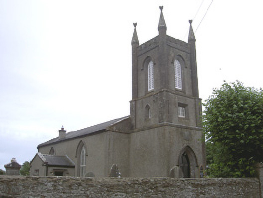
Freestanding Church of Ireland church, dated 1827. Two-bays to nave, projecting gable-fronted chancel to east, square-plan three-stage bell tower to west, projecting single-bay gable-fronted vestry to north. Pitched slate roof, clay ridge tiles, smooth rendered chimneystack, limestone verge coping, uPVC gutters on painted timber eaves board, circular cast-iron downpipes. Roughcast-rendered walling, smooth rendered, tooled ashlar limestone pinnacles and string courses to tower, ashlar limestone pediment surrounds to gables; carved limestone date plaque to bell tower. Pointed arch window openings, chamfered ashlar limestone reveals, carved limestone hood-mouldings, double lancet painted timber multiple-pane stained-glass windows, stained-glass leaded windows to tower, painted timber louvres to bell openings; square-headed window opening to vestry, chamfered ashlar limestone surround, paired painted timber multiple-pane window. Pointed arch door opening to tower, stop-chamfered ashlar limestone reveals, carved limestone hood-mould, painted timber door with four diagonally-sheeted panels, limestone flagstone and step; square-headed door opening to vestry, chamfered limestone reveals, hood-mould, timber sheeted door, concrete step. Church set back from road in surrounding burial ground; variety of cut stone grave markers c. 1825-1960, rubble stone boundary wall, wrought-iron gates. Rubble masonry corner-sited tower house to south-west corner of site.
This official record and map point do not grant access. Most recorded buildings are privately owned; view them only from public ground unless the owner allows entry.