Add your own picture and explain the route, parking, gates, paths or landmarks that help people find it.
Earn 5 points after the picture is checked and accepted.
Add your photo and local directionsShare what you foundWhat is recorded here
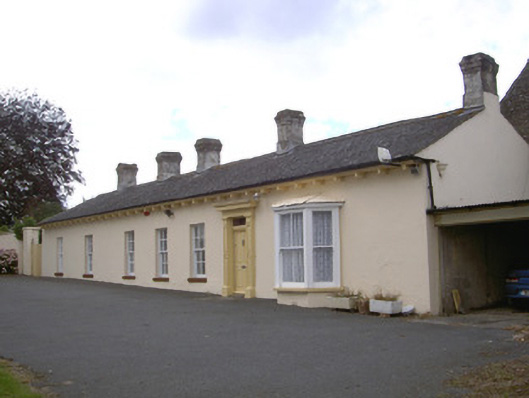
Detached seven-bay single-storey house, built c. 1830. Rectangular-plan, canted bay window c. 1900 to east of south elevation, two-bay flat-roofed garage extension to east. Pitched artificial slate roof, smooth rendered corbelled chimneystacks, uPVC rainwater goods, cast-iron hopper surviving to east elevation, projecting eaves, painted timber soffit on scrolled timber brackets. Painted smooth rendered ruled-and-lined walling. Square-headed window openings, rendered reveals, painted stone sills, painted timber six-over-six sliding sash windows, two-over-two and one-over-one sliding sash windows c. 1900 to canted bay. Square-headed door opening, painted timber surround, panelled pilasters having carved diamond motif, supporting corniced entablature, plain-glazed overlight, painted timber door with four raised-and-fielded panels, tooled limestone step to entrance. Two-storey outbuilding, pitched slate roof, rubble stone walling, abutting north-east corner. Farmyard to north comprising twelve-bay two-storey outbuilding, hipped slate roof, rubble stone walling, brick surrounds to window openings, limestone surrounds to loop windows, segmental-headed carriage arch openings and square-headed door openings, block-and-start ashlar limestone surrounds. Large walled garden to north-east, extensive rubble stone boundary walls to house and farmyard, segmental-headed gate opening to south wall of yard giving access to rear of house. House and farm complex set back from road in own grounds, rubble stone boundary walls, entrance gateway to south-west, rendered gate piers terminating in ball finials and rendered boundary walls.
This official record and map point do not grant access. Most recorded buildings are privately owned; view them only from public ground unless the owner allows entry.