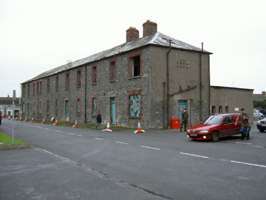
Add your own picture and explain the route, parking, gates, paths or landmarks that help people find it.
Earn 5 points after the picture is checked and accepted.
Add your photo and local directionsShare what you foundWhat is recorded here
Four detached eleven-bay two-storey stone barrack buildings, built c. 1825. Set around central parade yard; north-east building L-plan with single-storey flat-roofed extension to north, two- storey brick lean-to extension to north c. 1930, derelict single-storey flat-roofed extension to east; south-east building with concrete fire escape to north elevation c. 1970, hipped roof single-storey return to north-east, single-storey hipped roof stone porch to centre of east elevation, flat-roofed extension to south-east of east elevation c. 1960; single-storey stone and brick pitched roof return to north-west of south-west building; two-storey hipped roof rubble stone return to north-west of north-west building, lean-to rubble stone extensions to internal corner between return and main building on west elevation, hipped roof single-storey stone and brick return to south-west corner. Hipped artificial slate roofs to south-east, south-west and north-west buildings, clay ridge and hip tiles, red brick corbelled chimneystacks, extruded moulded aluminium gutters on limestone eaves corbel course, circular cast-iron downpipes; hipped slate roof to north-west block, stone ridge tiles, lead hip caps, red brick corbelled chimneystacks, extruded moulded aluminium gutters on limestone eaves corbel course, circular cast-iron downpipes. Uncoursed rubble stone walling, tooled ashlar limestone quoins. Square-headed window openings, red brick jambs and arches, limestone sills, painted timber casement windows c. 2003 to south-east, south-west and north-west blocks, fragments of painted timber sliding sash windows survive to north-east block, north and south windows on each east and west elevation are wider than intermediate windows. Square-headed door openings, plain stone surrounds, painted hardwood panelled door with plain-glazed overlights c. 2003 to south-east, south-west and north-west blocks; painted timber vertically-sheeted doors with four-pane overlights to north-east block. Gathered around parade ground, some cobbled surfacing, stone rainwater chutes at foot of rainwater downpipes.
This official record and map point do not grant access. Most recorded buildings are privately owned; view them only from public ground unless the owner allows entry.