Add your own picture and explain the route, parking, gates, paths or landmarks that help people find it.
Earn 5 points after the picture is checked and accepted.
Add your photo and local directionsShare what you foundWhat is recorded here
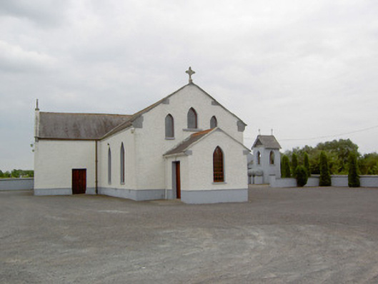
Detached Roman Catholic church on cruciform-plan, built c. 1830, remodelled c. 1970, having two-bay nave elevations (single-bay to south), single-bay transepts to the north and south and projecting chancel to the east (built c. 1909). Single-bay gable-fronted entrance porch attached to the nave gable (west), single-storey lean-to sacristy attached to the southwest side of chancel having single-bay flat-roofed addition to the south. Pitched slate roofs with clay ridge cresting, raised cut stone coping to gable ends having moulded limestone kneeler stones to eaves and carved limestone Celtic cross finials over gable apexes. Some remaining sections of cast-iron rainwater goods. Cut limestone eaves courses to nave, chancel and transepts. Pebbledashed walls over smooth rendered plinth course. Pointed arch window openings to nave and to gable ends of transepts having stone sills and replacement timber casement windows with timber intersecting tracery. Three graded pointed arch window openings to chancel gable having figurative stained glass windows. Three pointed arch window openings to nave gable (west) having simple stained glass windows. Square-headed door openings to north face of porch and to west elevations of transepts having with double leaf timber battened doors. Interesting interior with timber panelled gallery to west end of nave, supported on cast-iron posts and reached by carved timber staircase, carved Gothic Revival style timber confessional, wainscoted timber ceiling and marble altar, pulpit and reredos. Interior reordered c. 1970. Free-standing single-bay two-storey belfry to southeast corner of churchyard having pitched slate roof with wrought-iron cross finials and decorative timber bargeboards, smooth rendered walls and pointed arch openings at belfry level. Set back from road in own grounds to the southeast of Ballymahon with gravel forecourt to road-frontage to north. Rendered boundary walls to site, open to road-frontage to the north. Modern graveyard to the southeast having rendered boundary walls, wrought-iron gates and grave markers dating from c. 1917.
This official record and map point do not grant access. Most recorded buildings are privately owned; view them only from public ground unless the owner allows entry.