Add your own picture and explain the route, parking, gates, paths or landmarks that help people find it.
Earn 5 points after the picture is checked and accepted.
Add your photo and local directionsShare what you foundWhat is recorded here
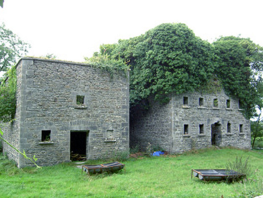
Former corn mill complex, built c. 1860, comprising a detached five-bay three-storey former corn mill to the north and a detached three-bay two-storey building adjacent to the south, possibly originally a corn kiln. Now out of use and derelict. Roofs now collapsed (probably originally hipped) having cut stone eaves courses to both buildings. Rubble limestone walls with flush squared dressed limestone block-and-start quoins to the corners of both structures. Square-headed window opening having flush dressed limestone block-and-start surrounds with prominent wedge-shaped keystones and having tooled limestone sills. Original window fittings no removed. Square-headed door openings to the centre of the east elevation of both buildings having flush dressed limestone block-and-start surrounds with prominent wedge-shaped keystones over. Segmental-headed relieving arches over both doorways having dressed limestone voussoirs. Set slightly back from road on the south bank of the River Inny, and to the southwest of Clynan Bridge (13402350). Former millrace runs east-west to the north of the former corn mill. Remains of former late medieval castle (LF023-123002-), later converted for use as a corn mill, on the opposite side of the river to the northeast.
This official record and map point do not grant access. Most recorded buildings are privately owned; view them only from public ground unless the owner allows entry.