Add your own picture and explain the route, parking, gates, paths or landmarks that help people find it.
Earn 5 points after the picture is checked and accepted.
Add your photo and local directionsShare what you foundWhat is recorded here
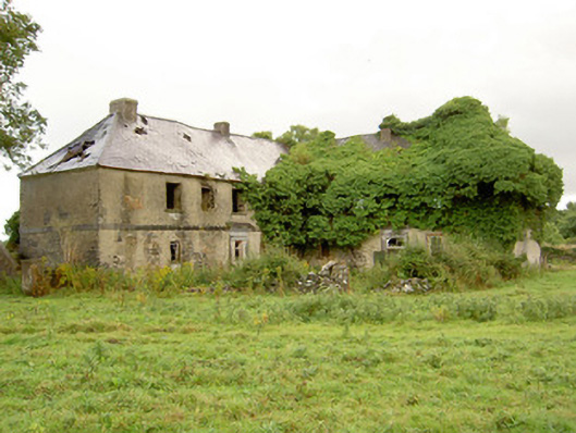
Detached multiple-bay two-storey house, built c. 1710 and probably incorporating the fabric of an earlier house to site c. 1660. Built on L-shaped plan comprising a five-bay two-storey range to the north with a four-bay two-storey range attached to the south end (running east-west). Later partially in use as stables, and later as a dwelling again until c. 1960. Now out of use, derelict and largely overgrown with vegetation. External flight limestone steps (on dog leg-plan) to north gable end of block to the north, having red brick wall to exterior face, giving access to doorway at first floor level to northeast corner (rear). Steeply pitched natural slate roofs with rendered chimneystacks, cast-iron rainwater goods and cut limestone eaves course. Roughcast rendered walls with cut limestone string course between floors and chamfered cut stone plinth course to base. Render now failing exposing rubble stone and squared rubble stone construction. Square-headed window openings with tooled limestone sills; window fittings now largely removed although a number of multiple-pan timber sliding sash window with exposed sash boxes set flush to front elevation remain in-situ. Number of window openings now blocked with brick infill. Square-headed door openings to front elevation (west) of north wing and to north elevation and west gable end of range to south wing. Carved limestone surrounds to door openings with architraves, and having flat friezes with moulded limestone cornices over. Remains of timber spoked fanlight to the doorway to the north elevation of wing to south. Some doorways now blocked with brick and rubble stone infill. Interesting interior with groin vaulted roof to ground floor supported on carved limestone Doric columns/pilasters. Set back from road in extensive mature grounds to the northeast of Ballymahon and the west of Abbeyshrule. Later complex of outbuildings (13402355) arranged around a courtyard to the northeast. Single-storey rubble stone outbuilding to the rear at the northeast end of range to north. Possible remains of late seventeenth-century or early eighteenth-century formal garden to the west and northwest of house (LF023-122----). Remains of walled garden on rectangular-plan to the southeast of house having rubble stone exterior walls faced internally with red brick having inlayed black brick diamond/diaper-work patterns. Similar diaper-work pattern to east face of support wall of flight of exterior stone steps to house. Rubble stone boundary walls to site. Dressed and roughly dressed limestone gate piers (on square-plan) to site, some having wrought-iron gates and pedestrian gates. Elaborate moulded limestone capstones to a number of gate piers (southeast of house), probably reused from an earlier building. Remains of long straight approach avenue (‘the Long Avenue’), c. 2 miles in length, runs to house from the north. Approach avenue now bisected by the Royal Canal a short distance to the north of the house.
This official record and map point do not grant access. Most recorded buildings are privately owned; view them only from public ground unless the owner allows entry.