Add your own picture and explain the route, parking, gates, paths or landmarks that help people find it.
Earn 5 points after the picture is checked and accepted.
Add your photo and local directionsShare what you foundWhat is recorded here
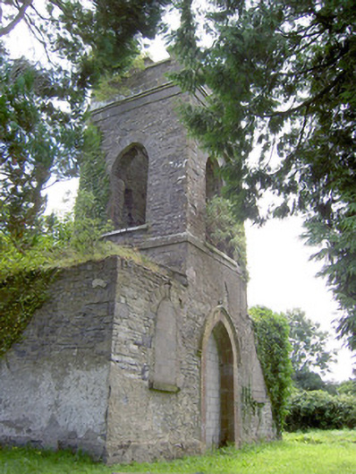
Freestanding former Church of Ireland church, built c. 1814 and altered c. 1860, having three-bay nave elevations (openings blocked), two-stage bell tower (on square-plan) to the northwest gable having flaking single-bay vestibules to either side (southwest and northwest) and apse to the chancel gable (southeast). Now roofless and disused. Largely overgrown with ivy. Roof now collapsed/removed, formerly pitched over nave and hipped over apsidal chancel. Roughcast render over roughly coursed limestone walls. Chamfered limestone plinth course to side vestibules. Crenellated parapet with cut stone coping over and carved ashlar limestone corner pinnacles (on square-plan) to bell tower. Projecting dressed limestone string course and eaves course to tower. Pointed arch window openings to front face of side vestibules having roughly dressed limestone voussoirs and dressed sills, now infilled with breeze block construction. Openings to side elevations of nave and to chancel now infilled and/or obscured by vegetation. Pointed arch openings to tower at belfry stage (second) having roughly dressed limestone voussoirs, opening to front elevation (northwest) set in blind square-headed recess. Fittings now gone. Pointed arch door opening to front face of tower (northwest) having chamfered limestone surround with carved limestone hoodmoulding over, now infilled with breeze block construction. Set back from road in own grounds to the southeast of Ardagh and the northwest of Legan. Surrounded by graveyard with collection of recumbent, upstanding and box-type grave markers dating to the nineteenth and twentieth century. Pebbledashed rubble stone boundary wall to road-frontage to the northeast, rubble limestone boundary walls elsewhere to site. Main entrance gateway to the northeast comprising a pair of pebbledashed gate piers (on square-plan) having cut limestone capping and double leaf wrought-iron gates. Associated rectory (134019201) adjacent to the southeast.
This official record and map point do not grant access. Most recorded buildings are privately owned; view them only from public ground unless the owner allows entry.