Add your own picture and explain the route, parking, gates, paths or landmarks that help people find it.
Earn 5 points after the picture is checked and accepted.
Add your photo and local directionsShare what you foundWhat is recorded here
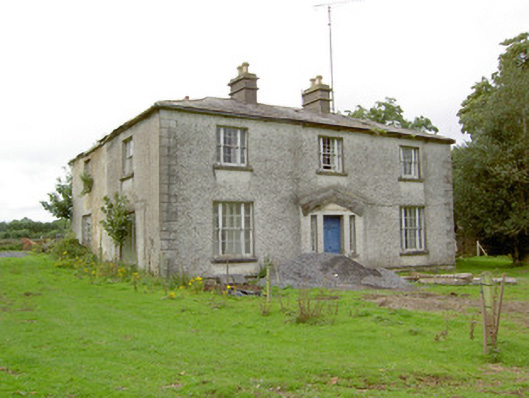
Detached three-bay two-storey house, built c. 1830 and altered c. 1865, on irregular plan having single- and two-storey blocks to rear (west), possibly incorporating fabric of earlier building(s). Wrought-iron tank to rear (west) to re-entrant corner (south side) of return. Now disused. Shallow hipped natural slate roof with a central pair of rendered chimneystacks to front block (east), having terracotta chimney pots over, and cast-iron rainwater goods. Two-storey block to rear with pitched slate roof having rendered rubble stone chimneystack to gable end to west. Pebbledashed walls over smooth render plinth course with render quoins to the corners. Lime roughcast rendered finish to single- and two-storey blocks to rear, now partially failing exposing rubble stone construction. Square-headed diminishing window openings to front elevation of front block (east) with tooled cut limestone sills and tripartite timber sliding sash windows comprising six-over-six panes flanking by two-over-two panes. Central square-headed door opening to main elevation (east) having timber panelled door flanked by fixed timber framed sidelights. Moulded cut stone step to front. Doorway formerly had pedimented Ionic doorcase, now removed. Set back from road in mature grounds to the east of Killashee and to the southwest of Longford Town. Complex of single- and two-storey outbuildings to the rear, built c. 1860. Two-storey multiple-bay outbuilding to the southwest having pitched natural slate roof, roughcast rendered rubble stone walls, and with loop hole and square-headed openings. Single-storey outbuilding to the northwest having pitched natural slate roof, partially roughcast rendered rubble stone walls, and square-headed openings, now blocked. Rendered rubble stone boundary walls and walls dividing yard to site, crenellated coping over boundary wall to the west. Modern farm buildings to the west side of yard. Main entrance gates to north of house comprising a pair of moulded sandstone gate posts having chamfered edges and moulded pyramidal heads, and with wrought-iron gates. Rendered walls to either side of main gateway.
This official record and map point do not grant access. Most recorded buildings are privately owned; view them only from public ground unless the owner allows entry.