Add your own picture and explain the route, parking, gates, paths or landmarks that help people find it.
Earn 5 points after the picture is checked and accepted.
Add your photo and local directionsShare what you foundWhat is recorded here
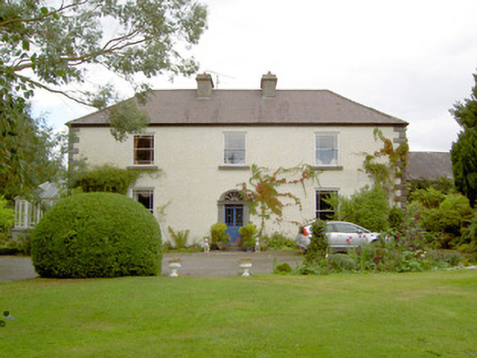
Detached three-bay two-storey house, built c. 1800, having two-storey block, and modern single- and two-storey extensions to rear (northwest), and modern glazed sunroom/conservatory attached to southwest elevation. Hipped natural slate roof with a central pair of ashlar limestone chimneystacks. Pebbledashed rendered walls over smooth rendered plinth course, and having V-profile cut limestone quoins to the corners of the main body of building. Square-headed window openings with tooled cut limestone sills and one-over-one pane timber sliding sash windows having margin glazing bars. Timber window shutters visible to interior. Central round-headed door opening to main elevation having glazed timber double doors, flight of cut limestone steps, and a carved limestone door surround comprising fluted pilasters with moulded capitals, moulded lintel/entablature with roundel motifs and fluted sections to frieze and having architraved head with petal fanlight. Set back from road in mature grounds to the northwest of Lanesborough, close to the banks of the River Shannon. Complex of single- and two-storey outbuildings to the rear (northwest), c. 1810, having pitched natural slate roofs and random rubble limestone walls (some with remnants of roughcast render over), and square-headed openings with timber battened doors and replacement timber casement windows. Round-headed window opening to south west gable end of outbuilding to the northeast of the house having brick surround and fixed-pane timber window. Main entrance gates to the south of house, possibly moved and rebuilt at present location, comprising a pair of ashlar limestone gate piers (on square-plan) having moulded pyramidal-headed capstones and a pair of hooped wrought-iron flat bar gates. Rubble limestone boundary walls to site. Pair of partially reconstructed dressed limestone gate piers (on square-plan) giving access to outbuildings to rear. Long approach avenue to house from the south.
This official record and map point do not grant access. Most recorded buildings are privately owned; view them only from public ground unless the owner allows entry.