Add your own picture and explain the route, parking, gates, paths or landmarks that help people find it.
Earn 5 points after the picture is checked and accepted.
Add your photo and local directionsShare what you foundWhat is recorded here
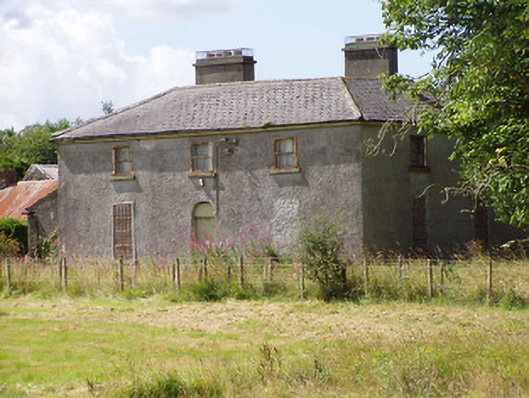
Detached three-bay two-storey house, built c. 1825, on L-shaped plan having two-storey return to rear (west) at the north end and a later two-storey block attached to the south end of the rear elevation, built c. 1860, having lean-to extension attached to south elevation. House currently disused. Hipped slate roof to main block having cast-iron rainwater goods and a central pair of rendered chimneystacks, aligned parallel to roof ridge. Projecting eaves course to main block. Pitched slate roof to the west end of block to the south end of the original house. Roughcast rendered finish over rubble stone construction. Square-headed window openings with two-over-two timber sliding sash windows to first floor, and square-headed openings with timber fittings to ground floor, now blocked (window opening to the north end of the front elevation at ground floor level now infilled and rendered over). Limestone sills to window openings. Central round-headed doorway to the main elevation (east) having timber battened door and blocked fanlight over. Complex of single- and two-storey outbuildings arranged around a courtyard to the rear, built c. 1860. Multiple-bay single-storey range to south, c. 1825 and extended to the west c. 1860, having pitched corrugated-metal roof and coursed rubble limestone masonry walls. Elliptical-headed carriage arches having brick voussoirs and painted keystones, with timber battened double doors having simple cast-iron strap hinges. Detached five-bay two-storey range to north, c. 1860, with lean-to to south elevation. Pitched natural slate roof with cast-iron rainwater goods. Coursed rubble limestone masonry walls. Square-headed window openings having roughly dressed limestone lintels and tooled limestone sills. Iron lattice-work fitting to window opening to the east end. Square-headed door openings with brick voussoirs and timber battened doors. Single-storey range to east having pitched corrugated-metal roof with brick chimneystack. Coursed rubble limestone masonry walls. Square-headed door openings with timber battened doors. Remains of former range to west having rubble limestone masonry and square-headed openings. Set back from road in mature grounds to the southeast of Longford Town. Entrance gateway to the north comprising a pair of cut limestone gate posts (on octagonal-plan) having pyramidal-shaped heads and a pair of wrought-iron flat bar gates with spear finials. Rendered boundary walls to road-frontage adjacent to entrance. Rubble limestone boundary walls to site, and along the approach avenue to the house from the north. Gateway to the east side of approach avenue to house comprising a pair of cut limestone gate posts (on octagonal-plan) having pyramidal-shaped heads and a pair of wrought-iron flat bar gates.
This official record and map point do not grant access. Most recorded buildings are privately owned; view them only from public ground unless the owner allows entry.