Add your own picture and explain the route, parking, gates, paths or landmarks that help people find it.
Earn 5 points after the picture is checked and accepted.
Add your photo and local directionsShare what you foundWhat is recorded here
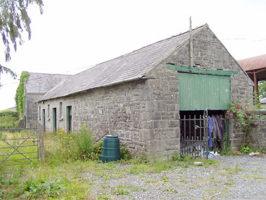
Complex of single-storey outbuildings formerly associated with Farragh/Farraghroe House (demolished c. 1960), built c. 1820 and c. 1850, arranged around a courtyard to the northwest of the site of the house. Now in use as farmyard. Detached six-bay single-storey range to north, c. 1820, with pitched natural slate roof, coursed roughly dressed limestone masonry walls and with flush dressed quoins to the corners. Square-headed window openings with flush dressed limestone block-and-start surrounds having fixed timber windows with limestone sills. Square-headed door openings with timber battened half-doors and flush dressed limestone block-and-start surrounds. Square-headed carriage arch to west gable end having timber lintel and double-leaf wrought-iron flat bar gates. Vents to south elevation, just below eaves. Six-bay single-storey range to south (two three-bay semi-detached buildings), c. 1850, having pitched natural slate roof with rendered end chimneystacks. Coursed roughly squared limestone masonry walls with dressed quoins to the corners. Square-headed window openings with replacement fittings and limestone sills. Square-headed door openings with replacement doors. Single-bay single-storey outbuilding to west having pitched natural slate roof and coursed roughly squared limestone masonry walls with dressed quoins to the corners. Square-headed carriage arch opening with replacement iron doors flanked by loophole openings. Set back from road to the southwest of Ballinalee and to the northwest of the site of Farragh/Farraghroe House. Rubble stone boundary walls, some with cut stone coping, to site. Gateway to the northeast comprising a pair of coursed squared limestone gate piers (on square-plan) having carved capstones and a pair of hooped wrought-iron flat bar gates.
This official record and map point do not grant access. Most recorded buildings are privately owned; view them only from public ground unless the owner allows entry.