Add your own picture and explain the route, parking, gates, paths or landmarks that help people find it.
Earn 5 points after the picture is checked and accepted.
Add your photo and local directionsShare what you foundWhat is recorded here
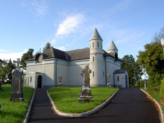
Detached T-plan Roman Catholic church, built c. 1820 and extensively remodelled between 1929 and 1933. Comprising single-bay nave, shallow projecting chancel to the southeast and single-bay transepts to the southwest and northeast. Engaged battered towers on circular-plan with conical roofs over flanking entrance gable (northwest) and projecting single-bay gable-fronted porch to the centre of the entrance gable. Single-bay flat-roofed entrance porches to transepts, single-storey flat-roofed sacristy to the rear (southeast). Sprocketed slate roof with lead roof and cross motif finials to barrel-vaulted dormer head windows. Conical concrete roofs to bell towers. Pebbledashed walls with smooth rendered pronounced concave eaves course and smooth rendered plinth course. Battered pebbledashed walls to bell towers with square-headed louvered openings to second stages. Oculus openings to dormer windows to eaves having decorative stained glass. Pointed arch openings to nave and transepts with painted stone sills and timber Y-tracery, having paired pointed arch seven-over-four timber sliding sash windows. Round-headed door openings to porches with double leaf timber battened doors. Carved marble altar and altar rail, with mosaic floor to altar area and decorative floor tiles to nave. Timber panelled galleries over nave and southwest transept, the former approached by timber staircase set in northeast bell tower. Figurative stained glass window to chancel gable. Set in own grounds and surrounded by graveyard (mainly to north) with collection of mainly upstanding nineteenth and twentieth century grave markers. Rendered boundary walls to road-frontage. Rendered gate piers (on square-plan) and wrought-iron gates to entrances. Located in an elevated position adjacent to crossroad junction. Located to the southeast of Ballinalee and to the southwest of Granard.
This official record and map point do not grant access. Most recorded buildings are privately owned; view them only from public ground unless the owner allows entry.