Add your own picture and explain the route, parking, gates, paths or landmarks that help people find it.
Earn 5 points after the picture is checked and accepted.
Add your photo and local directionsShare what you foundWhat is recorded here
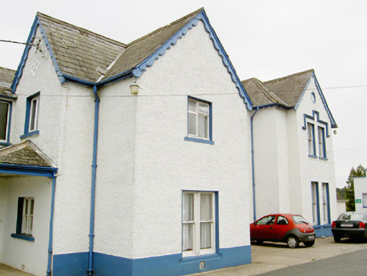
Detached multiple-bay two-storey former bishop's house on irregular-plan with various gable-fronted breakfronts/bays, built c. 1870. Subsequently used as a convent, later as a boarding school, and now in use as nursing home. Full-height three-bay canted projection to the northeast gable end. Various extensions to rear (north and northeast). Possibly incorporating fabric of earlier building. Pitched and hipped natural slate roofs with cut stone and rendered chimneystacks, cast-iron rainwater goods and decorative timber bargeboards to gable-fronted sections. Painted pebbledashed walls over smooth rendered plinth. Square-headed window openings, some paired, with mixed one-over-one pane timber sliding sash windows and replacement timber windows. Paired one-over-one timber sash windows to centre of principal elevation (southeast) with moulded render detailing over having quatrefoil motifs (giving impression of pointed arch window opening) with three-over-three pane timber sash window above at first floor level, set in pointed arch recess with inset quatrefoil motif. Continuous stepped label moulding over window opening at first floor level to gable-fronted section at the northeast end of principal elevation (southeast). Tripartite timber casement window to the southwest gable end at ground floor level. Square-headed door opening to the southwest end of principal elevation having replacement glazed timber door with plain overlight above. Projecting open lean-to porch to doorway supported on moulded cast-iron column. Single-storey outbuildings to rear with pitched and hipped natural slate roofs, rubble limestone walls (one now cement rendered), segmental-headed carriage arches and square-headed window and door openings. Located in own grounds to the north end of Newtown-Forbes. Rubble stone boundary wall to road-frontage.
This official record and map point do not grant access. Most recorded buildings are privately owned; view them only from public ground unless the owner allows entry.