Add your own picture and explain the route, parking, gates, paths or landmarks that help people find it.
Earn 5 points after the picture is checked and accepted.
Add your photo and local directionsShare what you foundWhat is recorded here
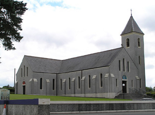
Detached Roman Catholic church on cruciform-plan, built 1907 and renovated in 1969, comprising five-bay nave to the northwest, full-height two-bay transepts to the northeast and southwest and a full-height shallow chancel to the southeast. Three-stage belltower on square-plan attached to the southeast side of the entrance elevation having slated spire with wrought-iron cross finial over. Single-storey vestry attached to the northeast side of chancel, c. 1969. Pitched artificial slate roofs with terracotta ridge crestings, cut stone cross finial to apex of roof to entrance gable. Corbelled eaves course to tower. Pebbledashed walls over smooth rendered plinth with strip/clasping buttresses to nave and transept. Round-headed window openings with leaded stained glass windows. Three graded round-headed lancet window openings to nave/entrance gable and to chancel gable. Square-headed door opening to centre of entrance gable with timber battened double doors and mosaic to semi-circular arch over above. Concrete steps with steel railings to front entrance. Interior has cross-braced timber truss roof, timber screen to entrance with timber gallery over, rendered chancel arch with granite colonnettes forming corbels. Marble altar with carved image of Christ to front panel. Set in own grounds to the northeast of the centre of Drumlish with burial plots of local clergy to site. Associated parochial house to the northeast. Rendered and pebbledashed boundary walls to road frontage with circular-profile piers and steel gates to entrance.
This official record and map point do not grant access. Most recorded buildings are privately owned; view them only from public ground unless the owner allows entry.