Add your own picture and explain the route, parking, gates, paths or landmarks that help people find it.
Earn 5 points after the picture is checked and accepted.
Add your photo and local directionsShare what you foundWhat is recorded here
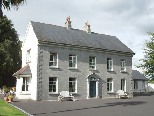
Detached five-bay two-storey former Church of Ireland rectory, rebuilt c. 1840, with canted bay to northwest elevation, and two-storey return to rear (northeast). Possibly incorporating the fabric of an earlier rectory, c. 1760, and altered c. 1763, 1791, 1795, and 1816. Now in use as private house. Single-storey extension to east elevation. Pitched natural slate roof with central pair of dressed stone chimneystacks. Moulded limestone eaves course to front elevation (southwest). Hipped slate roof to canted bay. Tooled ashlar limestone façade with raised limestone quoins to the corners, painted roughcast rendered walls elsewhere. Square-headed window openings with stepped carved limestone keystones, tooled limestone and concrete sills. Two-over-two pane timber sliding sash windows, paired timber sliding sash window to the northwest elevation at first floor level. Central round-headed entrance opening to main façade southwest) with carved limestone doorcase having pediment, scrolled brackets and moulded shouldered surround. Timber panelled entrance door with petal style fanlight over. Diagonally incised step and wrought-iron boot scrapes. Glazed timber double leaf door to bay. Rendered capped gate piers to the south having wrought-iron gates to entrance. Situated in extensive landscaped surrounds to the northwest of Longford Town centre. Ruins of former church (13008014) to the northwest of house.
This official record and map point do not grant access. Most recorded buildings are privately owned; view them only from public ground unless the owner allows entry.