Add your own picture and explain the route, parking, gates, paths or landmarks that help people find it.
Earn 5 points after the picture is checked and accepted.
Add your photo and local directionsShare what you foundWhat is recorded here
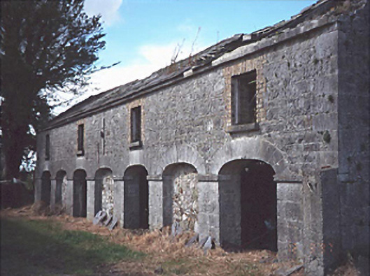
Farmyard complex, c.1850, including (north): Detached nine-bay single-storey stable outbuilding with half-attic on a rectangular plan. In ruins, 1997. Remains of pitched slate roof on collared timber construction with ridge tiles, coping to gables, and no rainwater goods surviving on cut-limestone eaves. Part ivy-covered coursed rubble limestone walls with cut-limestone flush quoins to corners. Square-headed door openings with yellow brick block-and-start surrounds. Segmental lunette window openings (half-attic) with cut-limestone sills, and yellow brick voussoirs with no fittings surviving. Square-headed window openings with cut-limestone sills, and yellow brick block-and-start surrounds with no fittings surviving; (south): Detached seven-bay two-storey coach house with half-attic on a rectangular plan. Derelict, 1997. Remains of pitched slate roof on collared timber construction with ridge tiles, coping to gables, and no rainwater goods surviving on cut-limestone eaves. Part ivy-covered coursed rubble limestone walls with cut-limestone flush quoins to corners. Series of seven elliptical-headed carriageways with limestone ashlar voussoirs. Square-headed window openings (first floor) with cut-limestone sills, and yellow brick block-and-start surrounds with no fittings surviving. Set in grounds originally shared with Sheffield. NOTE: Sheffield was demolished (1939) by the Irish Land Commission who subsequently advertised a 'SALE OF MATERIALS…by Public Auction [including] 3,800 slates, 22" x 12"; 2,200 slates, 18" x 10"; 4,200 slates, 14" x 8"; 600 slates, 30" x 18"; 286 ridge tiles, 27 windows, 24 doors, 5 mantle-pieces, 18 window shutters, 2 double doors, 1 ton lead…sash weights, scrap timber, building stone, cut stone, &c.' (The Nationalist and Leinster Times 19th August 1939).
This official record and map point do not grant access. Most recorded buildings are privately owned; view them only from public ground unless the owner allows entry.