Add your own picture and explain the route, parking, gates, paths or landmarks that help people find it.
Earn 5 points after the picture is checked and accepted.
Add your photo and local directionsShare what you foundWhat is recorded here
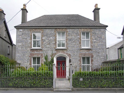
Detached three-bay two-storey L-plan house, built c.1895, with enclosed front garden Renovated c. 2000. Hipped artificial slate roof, synthetic ridge tiles, pair of ruled-and-lined rendered tall chimneystacks rising from both side elevations with octagonal clay pots, replacement metal rainwater goods to timber eaves. Render removed from front elevation exposing rubble limestone walling, tooled and squared limestone finish quoins, smooth rendered plinth course, yellow brick in and out work to all openings, painted pebbledash rendered walling to side and rear elevations. Square-headed window openings formed in brick with rubbered brick flat arches, painted stone sills, patent rendered reveals, replacement two-over-two timber sash windows. Round-headed window opening to rear, lighting stairwell, with single-pane timber sash window having margin lights and coloured glass. Replacement timber casement windows to rear. Central segmental-headed door opening with deep rendered reveals to inset door, replacement timber panelled and glazed door and overlight. Opening onto limestone step and stone-flagged footpath through front lawn enclosed to either sided by tall rendered wall, enclosed to street by tall cast-iron railing on cement plinth, pair of decorative cast-iron piers with cap moulding and pedestrian iron gate having original limestone step to pavement.
This official record and map point do not grant access. Most recorded buildings are privately owned; view them only from public ground unless the owner allows entry.