Add your own picture and explain the route, parking, gates, paths or landmarks that help people find it.
Earn 5 points after the picture is checked and accepted.
Add your photo and local directionsShare what you foundWhat is recorded here
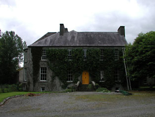
Detached five-bay two-storey over part-raised basement former mill owner's house with dormer attic, c.1840, originally four-bay with door opening approached by flight of steps. Extended, c.1880, comprising single-bay two-storey over basement end bay to south-east having single-bay full-height bowed bay to side elevation to south-east and two-bay three-storey over raised basement return to rear to south-west forming L-shaped plan. Extended, c.1950, comprising single-bay two-storey over raised basement flat-roofed return to rear to north-west. Now in private residential use. Hipped roofs with slate (gable-ended to north-west; half-conical to bowed bay to south-east). Clay ridge tiles. Rendered chimney stacks. Iron rainwater goods. Flat-roof to additional return. Bitumen felt. Roughcast walls. Unpainted. Square-headed window openings. Stone sills. 1/1, 2/2, 6/6 and 9/6 timber sash windows. Square-headed door opening approached by flight of stone steps. Cut-stone surround. Timber panelled door. Set back from road in own grounds. Tarmacadam forecourt to front.Attached nine-bay single-storey rubble stone outbuilding with attic, c.1840, to west originally detached. Gable-ended roof with slate. Clay ridge tiles. Cast-iron rainwater goods. Rubble stone walls. Painted. Square-headed openings. No sills. Timber lintels. Timber casement windows. 1/1 timber sash windows to side elevation to east. Timber boarded doors.Detached ten-bay single-storey rubble stone outbuilding with half-attic, c.1840, to west. Reroofed, c.1950. Gable-ended roof. Replacement corrugated-iron, c.1950. Iron ridge tiles. Iron rainwater goods. Rubble stone walls. Traces of paint over. Square-headed openings. Cut-stone sills and lintels. Yellow brick dressings. Timber fittings.Detached four-bay two-storey rubble stone outbuilding, c.1840, to west on an L-shaped plan comprising two-bay double-height range with square-headed integral carriageway having two-bay two-storey range at right angles to east. Gable-ended roof on an L-shaped plan with slate. Clay ridge tiles. Rendered chimney stack (over part replacement concrete block construction). Iron rainwater goods. Rubble stone walls. Painted. Square-headed openings. Cut-stone sills and lintels. Fittings now gone.Internal gateway, c.1840, to west comprising pair of cut-granite piers with moulded capping. Gates now gone.Mill race, c.1840, to south with rubble stone retaining walls. Remains of cast-iron waterwheel, c.1840, to south retaining some early mechanisms. Now disused.Three-span rubble stone road bridge, c.1840, over mill race with wrought iron railings. Rubble stone walls. Wrought iron railings to parapet walls. Three flat spans on squat stone piers. Cut-stone lintels.Gateway, c.1840, to north comprising pair of cast-iron piers with wrought iron gates and railings.
This official record and map point do not grant access. Most recorded buildings are privately owned; view them only from public ground unless the owner allows entry.