Add your own picture and explain the route, parking, gates, paths or landmarks that help people find it.
Earn 5 points after the picture is checked and accepted.
Add your photo and local directionsShare what you foundWhat is recorded here
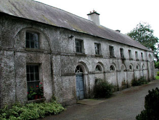
Detached nine-bay two-storey building, c.1775, on a T-shaped plan possibly originally part of larger building retaining early aspect with series of round-headed openings to ground floor, single-bay two-storey advanced bays to side elevations having full-height round-headed recessed niches with single-storey round-headed flanking niches, and three-bay two-storey return to rear having single-bay two-storey projecting bay with full-height round-headed recessed niche to side elevation. Hipped roofs with slate. Clay ridge tiles. Rendered chimney stacks. Square rooflights. Moulded eaves band. Cast-iron rainwater goods. Roughcast walls over rubble stone construction (exposed rubble stone construction to side elevations and to part of return). Stringcourse to spring of round-headed openings and to first floor. Round-headed recessed niches (single-storey and full-height) to various elevations. Square-headed window openings. Stone sills. Continuous sill course to first floor. 1/1, 2/2, 3/3 and 6/6 timber sash windows. Series of round-headed openings to ground floor (including door opening). Timber panelled double doors. Spoked fanlights to all round-headed openings. Set back from road in own part-overgrown grounds. Gravel verge to front.Detached five-bay single-storey rubble stone outbuilding with half attic, c.1775, to site. Now disused and part derelict. Gable-ended roof with slate. Clay ridge tiles. Eaves band. Rainwater goods now gone. Rubble stone walls. Red brick dressings. Shallow segmental-headed window openings. Stone sills. Red brick to heads. Fittings now gone. Remains of shallow segmental-headed integral carriageways. Red brick dressings. One now blocked-up (rubble stone) with one remodelled, c.1900, having lintel added forming square-headed opening. Fittings now gone.
This official record and map point do not grant access. Most recorded buildings are privately owned; view them only from public ground unless the owner allows entry.