Add your own picture and explain the route, parking, gates, paths or landmarks that help people find it.
Earn 5 points after the picture is checked and accepted.
Add your photo and local directionsShare what you foundWhat is recorded here
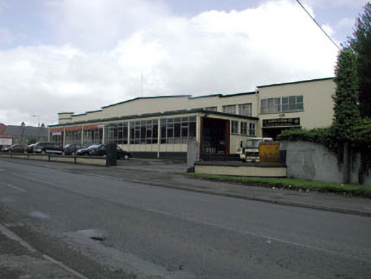
Detached ten-bay double-height factory, built 1936, on a corner site on an almost-symmetrical plan comprising four-bay double-height flat-roofed central block with two-bay double-height flanking roofed flanking bays, single-bay double-height end bay to left (east) having single-bay full-height canted bay window, single-bay double-height end bay to right (west), and ten-bay double-height range to rear to south. Renovated, c.1950, with six-bay single-storey flat-roofed projecting entrance block added to centre. Part refenestrated, c.1990. Now in commercial use. Flat-roofed to original entrance block behind parapet walls. Materials not visible. Gable-ended (saw-tooth) roofs to range to south with corrugated-asbestos. Concrete ridge tiles. Cast-iron rainwater goods. Flat-roofed to additional entrance block. Bitumen felt. Rendered and roughcast walls. Painted. Rendered parapet walls to original entrance block with moulded rendered coping. Square-headed window openings. Stone sills. Some original iron casement windows. Replacement uPVC casement windows, c.1990, to remainder. Oculus widows to gables to range to south. Fixed-pane iron windows. Square-headed door openings. Timber panelled double doors. Overlights. Set back from road in own grounds on a corner site. Section of cast-iron railings to front (north) on rendered plinth wall having rendered piers.
This official record and map point do not grant access. Most recorded buildings are privately owned; view them only from public ground unless the owner allows entry.