Add your own picture and explain the route, parking, gates, paths or landmarks that help people find it.
Earn 5 points after the picture is checked and accepted.
Add your photo and local directionsShare what you foundWhat is recorded here
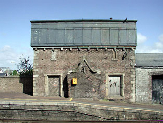
Freestanding three-bay two-storey red brick former water tower, c.1875, with single-bay single-storey gabled advanced porch to centre and cast-iron water tank over. Now disused. Cast-iron section tank to roof on corbelled eaves with ‘pilaster’ strips having rosette motifs and consoles cornice. Red brick Flemish bond walls. Cut-granite dressings including quoins to corners. Cut-granite coping to parapet wall to advanced porch. Cut-granite corbelled eaves course. Square-headed window openings (slit-style to first floor). Cut-granite chamfered sills and block-and-start surrounds. Now blocked-up (red brick). Outline of pointed-arch door opening. Now blocked-up (red brick). Set back from road in grounds shared with Sallins (and Naas) Railway Station flanking platform to north-west.Attached single-bay single-storey rubble stone outbuilding, c.1880, to north-east. Now disused. Gable-ended roof with slate. Clay ridge tiles. Timber eaves. Coursed rubble limestone walls. Cut-stone quoins to corners. Square-headed door opening. Cut-stone sill. Red brick dressings. Boarded-up. Shallow segmental-headed door opening. Red brick surround. Boarded-up.
This official record and map point do not grant access. Most recorded buildings are privately owned; view them only from public ground unless the owner allows entry.