Add your own picture and explain the route, parking, gates, paths or landmarks that help people find it.
Earn 5 points after the picture is checked and accepted.
Add your photo and local directionsShare what you foundWhat is recorded here
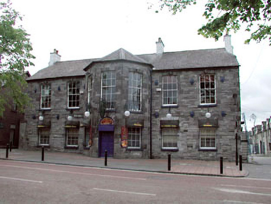
Detached five-bay two-storey former hotel, built 1777, retaining early fenestration with single-bay two-storey canted projecting entrance bay to centre, two-bay two-storey parallel return to rear (south-east) elevation forming double-pile section and three-bay two-storey parallel block to rear to east. Now in alternative commercial use. Hipped gabled roof with slate (half-octagonal to canted projecting entrance bay; hipped and gable-ended to parallel return; hipped to parallel block). Clay ridge tiles. Rendered chimney stacks. Cast-iron rainwater goods on eaves course. Irregular coursed squared limestone walls. Cast-iron tie plates. Limestone ashlar walls to canted projecting bay. Rendered walls to side (south-west) and to parallel ranges to rear (south-east). Painted. Square-headed window openings. Stone sills. Cut-stone block-and-start surrounds. 6/6 timber sash windows (6/9 timber sash windows to first floor canted projecting bay possibly in elongated openings). 1/1, 3/6 and 6/6 timber sash windows to parallel ranges. Round-headed window openings to side elevation to north-east. Stone sills. Red brick surrounds. Fixed-pane timber windows. Round-headed door opening. Cut-stone voussoirs. Replacement timber panelled double doors, c.1990, retaining early brass knockers with timber overpanel. Road fronted. Concrete brick cobbled footpath to front. Laneways along side elevations to north-east and to south-west. Rubble grounds to rear (south-east).
This official record and map point do not grant access. Most recorded buildings are privately owned; view them only from public ground unless the owner allows entry.