Add your own picture and explain the route, parking, gates, paths or landmarks that help people find it.
Earn 5 points after the picture is checked and accepted.
Add your photo and local directionsShare what you foundWhat is recorded here
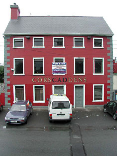
Detached five-bay three-storey double-pile building, c.1840. Extensively renovated and extended, c.1980, comprising five-bay single-storey parallel return to rear to south-west to accommodate commercial use. Now disused. Gable-ended double-pile (M-profile) roof (gable-ended to parallel return). Replacement artificial slate, c.1980. Red clay ridge tiles. Rendered chimney stacks. Replacement plastic rainwater goods, c.1980, on rendered eaves course. Rendered walls. Painted. Rendered quoins to corners. Square-headed openings. Stone sills. Rendered surrounds (moulded to ground floor). Replacement timber casement windows, c.1980. Replacement timber panelled doors, c.1980. Overlights. Road fronted. Concrete footpath to front.Detached multiple-bay single-storey rubble stone outbuilding with half-attic, c.1840, to south-west with outlines of segmental-headed integral carriageways. Now disused. Gable-ended roof with slate. Clay ridge tiles. Rainwater goods now gone. Rendered eaves course. Random rubble stone walls. Dressed stone quoins to corners. Square-headed window openings (some slit-style with yellow brick dressings). Stone sills. Some openings now blocked-up (concrete block) with fittings to remainder not discerned. Outline of segmental-headed integral carriageways to north-west. Dressed stone voussoirs. Now blocked-up (concrete block).
This official record and map point do not grant access. Most recorded buildings are privately owned; view them only from public ground unless the owner allows entry.